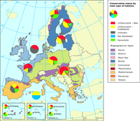
How to read the map: in the Mediterranean biogeographical region, about 21 % of habitats are in favourable conservation status, but 37 % are in unfavourable (bad plus inadequate) status.

The Elevation breakdown is used to allocate land cover changes into homogeneous areas as function of height, slope and distance to the sea
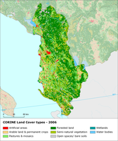
Based on common template, EEA has analyzed the Corine Land cover 2006 data and provides graphs and maps with concise characterization of land cover changes in 38 EEA member and collaborating countries. Provided information does not represent reporting from the Countries, however it is based on validated CLC2006 data.

Complete coastline features for all the countries that produced Corine land cover 2000 and have a coastline, with detailed descriptions on the environment and type of coastal areas

EEA has reprojected the grid used by EMEP for analyses on air emissions (150*150 km2 and 50*50 km2 grids covering Europe)

The Corine biotopes shape files and database is an inventory and location of major nature sites in the Phare countries (Albania, Bulgaria, Czech Republic, Estonia, Hungary, Latvia, Lithuania, Poland, Romania, Slovakia, Slovenia). The database is part of the Corine biotopes project to enhance reliable and accessible information about vulnerable ecosystems, habitats and species of importance as background information for Community environmental assessment.

The map is made using the global digital elevation model (DEM) derived from GTOPO30. Note that the values in the file are not the original elevation data. The data has been processed to create an image for presentation purposes streching a predefined colour template over the derived values.

The Corine biotopes (Version 2000) database is an inventory of major nature sites
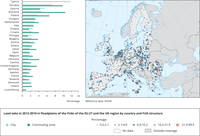
Left chart: The extent of land take during 2012-2018 (in % of the 2012 value) in floodplains of the FUAs is presented in the barchart, broken down by countries and protection type. The dataset covers the entire EEA-39 region but the figure only presents EU-27+UK countries.
Right map: Land take is derived from comparing the Urban Atlas 2012 and 2018 datasets of the Copernicus Land Monitoring Service. Land take is expressed as the converted area in % of the 2012 land cover extent (% of non-urban land cover in 2012 that is converted to urban land cover by 2018). The dataset covers the entire EEA-39 region but the Figure only presents EU-27+UK countries.
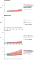
The index reports the total number of days per year with a critical level of fire danger. Fire danger is based on the Canadian Fire Weather Index (FWI) which is one of the most commonly used fire indices globally. It is based on a numerical rating of the potential frontal fire intensity and combines the rate of fire spread with the amount of fuel being consumed. The calculation of FWI requires several meteorological input variables (see the ETC-CCA Technical Paper for details).
FWI values are classified into several fire danger classes. According to the classification of the European Forest Fire Information System (EFFIS; EC, 2020), FWI values in the range 11.2-21.3, 21.3-38 and 38-50 represent ‘moderate’, ‘high’ and ‘very high’ fire risk, respectively. However, different classifications are being used at national levels. The index presented here shows the annual number of days with high fire danger conditions (defined as daily FWI values above 30 in the underlying CDS dataset).
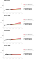
The frequency of extreme precipitation refers to the total number of days in a year with total precipitation exceeding the 99th percentile of the daily precipitation values during the reference period. Other implementations of this index may use a different percentile (e.g., 95th) depending on the level of rarity of events to be considered.
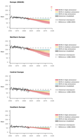
The frost days index is defined as the number of days in a year with a daily minimum temperature below 0°C. Variations of this index limit the counting of frost occurrences to particular seasons (e.g., the growing season or the spring months). A closely related index is ‘ice days’, which uses daily maximum instead of minimum temperature.
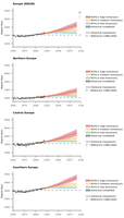
The growing degree days index represents a measure of the accumulated heat available for vegetation growth. It is calculated as the accumulated sum over the year of the daily mean temperature exceedances of a base threshold (see the ETC-CCA Technical Paper for details). A base temperature of +5 °C is considered as representative for most European crops. Other definitions of the index are possible, including variations of the minimum temperature, the use of an upper temperature threshold, and restrictions to a given growing season.
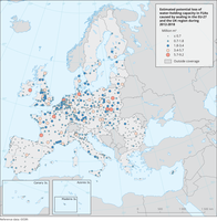
The map visualizes water holding capacity loss due to the estimated soil sealing increase during 2012 and 2018 in FUAs. Although the figure presents EU27+UK values only, data is available for the EEA-38 region and the UK.
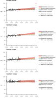
The maximum consecutive five-day precipitation index accounts for the greatest precipitation total over five consecutive days in a year.

Mean temperature is a base index representing the average air temperature over different timescales (e.g., seasonal or annual). This index is well covered by data for past, present and future periods from both observations and model simulations.

The map illustrates groundwater bodies of poor chemical status, affected significantly by diffuse source pollution from agriculture in the EU-27, as reported in national 2016 RBMPs.
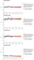
Mean wind speed is a base index accounting for the average values of wind speed at 10 m height over longer timescales (e.g., seasonal or annual).
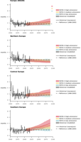
The duration of meteorological droughts represents the average number of months in a year experiencing drought conditions as determined by anomalously low precipitation values. The index is based on the Standardized Precipitation Index aggregated over three months (SPI-3), which accounts for the deficit or surplus of precipitation with respect to a reference period. Alternative aggregation periods for SPI can be used depending on the type of drought considered and the specific applications. SPI values represent standard deviations of precipitation from the long-term mean. A drought event is considered to start when SPI values fall below -1 for at least two consecutive months and to end when the index returns to a positive number (see the ETC-CCA Technical Paper for details).