All official European Union website addresses are in the europa.eu domain.
See all EU institutions and bodiesAn official website of the European Union | How do you know?
Environmental information systems
EN
As the European Environment Agency (EEA) marks 35 years of CORINE Land Cover (CLC), we spoke with Andrus Meiner, head of the Earth Observation Unit at the EEA and one of the longest-serving contributors to the dataset, about how it began, how it has evolved, and why it continues to matter today.
What exactly is CORINE Land Cover?
CORINE is an acronym for Coordination of Information on the Environment. It was launched by the European Commission in the 1980s to generate harmonised, geographically comparable environmental information across Europe.
Several CORINE themes existed — air, water, soil — but CORINE Land Cover is the one that has endured. The first data, collected for the reference year 1990, was integrated into the EEA’s work programme in 1994 and remains one of the most recognisable European environmental datasets.
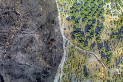
Land cover describes biophysical features on the Earth’s surface — forests, croplands, grasslands, built-up areas — as seen from above (from satellite, for example). It differs from land use, which describes how the land is used. CLC is unusual in that it combines both aspects. This mixture has sometimes been criticised, but in practice it has proved extremely useful because it adds thematic nuance necessary for monitoring implementation of environmental policies.
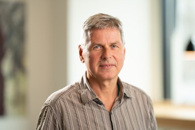
Andrus Meiner
Head of the Earth Observation Unit
What made CLC innovative when it was first created 35 years ago?
Partly the use of satellite imagery, which was still relatively new. But equally important was the European collaboration behind it. CLC is a genuine pan-European co-creation: national teams mapped their territories following common guidance, and even mapped slightly beyond their borders to ensure seamless continuity.
This effort created a dataset without the typical “border effects” seen in many international products.
The sixth CLC dataset is now on its way. What can users expect?
The next CLC dataset will have reference year 2024, based on satellite images acquired mainly that year. We plan to release it in mid-2026.Despite technological progress, the key parameters have remained constant since 1990: 44 land-cover/land-use classes, the same minimum mapping unit and a stable methodology.
Because of this consistency, we can now look back at 35 years of landscape change through a continuous, comparable time series. This is something no other region in the world has achieved at this scale.
How is CLC used today?
CLC is widely used for: ecosystem mapping and ecosystem accounting, long-term landscape and urbanisation analyses, forest and agro-environment assessments, applications where time series of land-related changes are needed.
It is free to use and remains valuable even as newer, more detailed Copernicus land monitoring datasets have been developed. Those newer datasets offer higher spatial resolution, but they cannot replace the long-term continuity and thematic richness of CLC.
Are you still using the same satellite systems as in the early days?
Not anymore. We began with Landsat satellites. Today we rely mainly on Copernicus Sentinel imagery and other modern sources.
But an essential feature has stayed the same: CLC is co-created with countries. National teams refine the satellite images interpretation using their own datasets — for example soil maps, forest inventories or topographic data. This helps capture features that satellite imagery alone cannot distinguish.
What is next for CLC?
A few years ago, we considered discontinuing it, mostly due to concerns about spatial detail. But users across Europe strongly requested that the time series continue.
As a result, we are planning to reduce the production cycle from six years to three, while keeping the core methodology unchanged to preserve comparability.
In the Copernicus portfolio, CLC is evolving from a general-purpose dataset into a specialised long-term baseline that complements newer, higher-resolution products.
Does the EEA use CLC directly in its work?
Yes. CLC is essential for the EEA’s ecosystem accounting work, which is linked to new EU legislation. It is also used to analyse nature protection and restoration trends when long-term change is the focus.
When someone asks, “How has this Natura 2000 site changed over the last 25 years?”, CLC is often the only dataset that can provide a complete answer.
You have been working with CLC from the very beginning. How did it all start for you?
My involvement began with the very first CLC dataset, which has a reference year of 1990. At that time, I was the project manager for Estonia’s first national land cover dataset — the first ever produced for the country. I supervised the work as part of an EU-funded effort, even before Estonia joined the EEA and EU.
That was my introduction to CLC and it has stayed with me ever since.
What was it like to work on CLC in the 1990s?
Very different from today. The satellite images were printed on large sheets of paper. Interpreters placed transparent plastic overlays on top and traced the visible landscape features with ink pens. Each patch received a code assigning it to a CLC land category.
If something was unclear, they consulted national maps — soil, forest, topographic — to refine the interpretation. All sheets with identified polygons were later scanned and merged into a digital database.
Estonia also needed specific subclasses for features uncommon in Central Europe, such as natural raised bogs, forests on peat, and extensive coastal reed beds. We documented these in a national CLC manual, complete with examples and photographs. Because the concept of land cover did not exist in Estonian at that time, I even had to invent the word for it: maakate. It is now used widely.

After 35 years, what has stayed with you the most?
The sense of community. The people who worked on CLC — some of whom joined our celebration at the EEA last month — developed a shared way of thinking shaped by years of cooperation and problem-solving.
Once CORINE Land Cover, always CORINE Land Cover.
When we started it just felt exciting. Today, there is pride in knowing that we built something unique in the world: a consistent, long-term picture of Europe’s changing landscapes, created together and still serving European policy today.