All official European Union website addresses are in the europa.eu domain.
See all EU institutions and bodies
An official website of the European Union | How do you know?
Environmental information systems
About 80% of Europe’s land surface has been shaped by human activities: covered with buildings, roads, industrial infrastructure or used for agriculture. The way we use land constitutes one of the main drivers of environmental degradation and climate change.
Europe is one of the most intensively used landmasses on the globe, with the highest share of land used for agriculture, forests and, to a lesser extent, urban areas and infrastructure. The way we use this invaluable resource has significant impacts on the environment and climate change.
Land use remained relatively stable in the EU, except for artificial surfaces such as built areas and roads, with an increase of over 6% during 2000-2018.
The increasing land-take trend (change in agricultural, forest and other semi-natural land taken for urban and other artificial land development) puts pressure on biodiversity, degrades habitats and contributes to issues ranging from carbon sequestration to soil sealing, landscape fragmentation, increased flood risk and urban heat island effects.
Forests cover close to 40% of Europe's land area. Besides providing food, fibres and habitats for many species, they contribute to the annual net removals of greenhouse gas. Through its land use, land use change and forestry (LULUCF) activities, the EU currently removes a net total of 244 Mt CO2e from the atmosphere every year, equivalent to 7% of its annual greenhouse gas emissions. The sector will play a crucial role in helping the EU achieve net zero emissions by 2050.
Organic soils, including peat lands, store large quantities of carbon and they are therefore equally important for land-based mitigation efforts.
Assuring that land is used in a sustainable way requires a long-term management perspective leading to a transition to sustainably managed land.
Press releases and articles
Publications
Indicators
Maps and charts
Datahub
Frequently asked questions
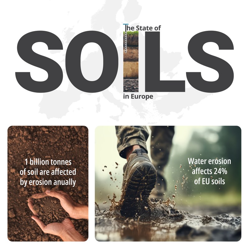
Urgent action needed to reverse soil degradation in Europe
Soil degradation threatens our competitiveness, food security, agricultural productivity, biodiversity, and resilience to extreme weather events and climate change. Joint efforts at EU, national, and local level focus on restoring soil health.
Launched at the EU Soil Observatory Stakeholder Forum, the 2024 State of Soils in Europe report assesses the state of soil degradation across the EU and other countries in the European Economic Area, including Ukraine, Türkiye, and the Western Balkans. The report shows alarming status and trends, with soil degradation getting much worse in recent years, and highlights the need for immediate action to reverse this trend.
The State of Soils in Europe report is a collaboration between the Joint Research Centre and the European Environment Agency.
Interview — What satellites can tell us about Earth
Sentinel—2C provides continuity for Sentinel—2A. The European Union's Copernicus programme is vast and long-term maintenance needs to be an essential part of the plan. Sentinel—2C will ensure continuity in the data, bridging the time between Sentinel—2A, 2B, and eventually 2D. These satellites work in pairs, providing a solid foundation for our work at Copernicus Land Monitoring Service (CLMS). ... Continuity is crucial for the kind of long-term monitoring we do at CLMS and the European Environment Agency (EEA).

Expert - Copernicus Project Lead
Copernicus EU
What is Copernicus Land Monitoring Service?
Copernicus is the European Union's Earth observation programme. Information from this programme is provided through six thematic services: land, marine, atmosphere, climate change, emergency management and security. All information is free and openly accessible to all users. The Land Service, provided by the EEA and the European Commission's Joint Research Centre, is divided into four main components: global , pan-European, local and imagery and reference data.
Copernicus land data provides detailed information, for example, on ground motion or how urban areas, forests, snow and ice cover change over time.
Forests cover close to 40% of Europe's land area.
ImagePedro Esteves, Well with Nature /EEA
What happens when we cover the ground with concrete and asphalt?
European cities are growing, and with them a larger area has been covered by concrete, asphalt, buildings or other artificial surfaces. Since the mid-1950s, the total surface area of cities in the EU has increased by 78%, thus contributing greatly to soil sealing and its negative impacts.
Soil sealing can be defined as the destruction or covering of the ground by an impermeable material. It is one of the main causes of soil degradation in the EU.
Soil sealing often affects fertile agricultural land, puts biodiversity at risk, increases the risk of flooding and water scarcity and contributes to global warming.
Almost half the area of cities is sealed and about 4% of the EU's coastal regions and floodplains are impermeable, jeopardising adaptation to heatwaves and floods and decreasing carbon sequestration.

Edgaras Vaicikevicius, My City/EEA
More information
Other topics you might be interested in:
External links:
- Climate and energy portal: Land use and forest data
- Copernicus Land Monitoring Service (CLMS)
- European Spatial Planning Observation Network (ESPON)
- European Nature Information System (EUNIS)
- Biodiversity Information System for Europe (BISE)
- Forest Information System for Europe (FISE)
- Global Forest Resources Assessment (GFRA)