All official European Union website addresses are in the europa.eu domain.
See all EU institutions and bodiesAn official website of the European Union | How do you know?
Environmental information systems
EN
Methods to estimate GHG emissions and removals can vary significantly regarding the level of complexity. The IPCC Guidelines refer to different “Tier levels” ranging from the use of global default values and international statistics (Tier 1) to the use of country specific data (Tier 2) and advanced methods based on data from field measurements and modelling (Tier 3).
Using higher Tier methods improves the accuracy and usefulness of land sector GHG reporting by capturing the effects of detailed management practices, distinguishing policy and natural impacts, enabling projections for multiple policy purposes, and providing broader insights despite requiring more data and assumptions.
The LULUCF Regulation requires that Member States prepare high-quality, accurate GHG inventories. Currently 15% of reported emissions and removals in the EU are estimated using a Tier 1 methodology. Tier 2 methodologies account for 62% and Tier 3 methodologies for 23% (NIDs for 2023). How to advance methodologies towards the integration of more national data and the use of detailed measurements and modelling depends on data being available and data infrastructure, but also the capabilities of the reporting systems used to incorporate better data.
What are Tier levels?
Tier levels refer to the methodological complexity used to estimate GHG emissions and removals. The IPCC provides three tiers, increasing in detail, data needs and accuracy:
- Tier 1 methods use readily available statistical data and default emission factors from the IPCC Guidelines. Tier 1 emission factors also assume typical processes on land areas for certain regions. This method is often not very accurate for emissions and removals from land use and land use changes.
- Tier 2 methods are similar to Tier 1 in terms of methodologies, but default emission factors are replaced with country-specific emission factors. These are being developed on the basis of knowledge of the types of processes and specific conditions that apply in the country for which the inventory is being developed. This method should lead to an improvement of estimates over Tier 1 because default values proposed for Tier 1 are based on a large spectrum of references that are not always representative for individual Member States.
- Tier 3 methods are more complex, they encompass country-specific methodologies with high resolution. Tier 3 methods can entail repeated measurement campaigns (e.g. National Forest Inventories) or specific modelling approaches calibrated and validated for the country against measurements (e.g. biomass models). If properly validated, the modelling method will lead to an improvement of estimates over Tier 1 and 2 because it better reflects the temporal dynamics and fills data gaps that exist at lower-level methods.
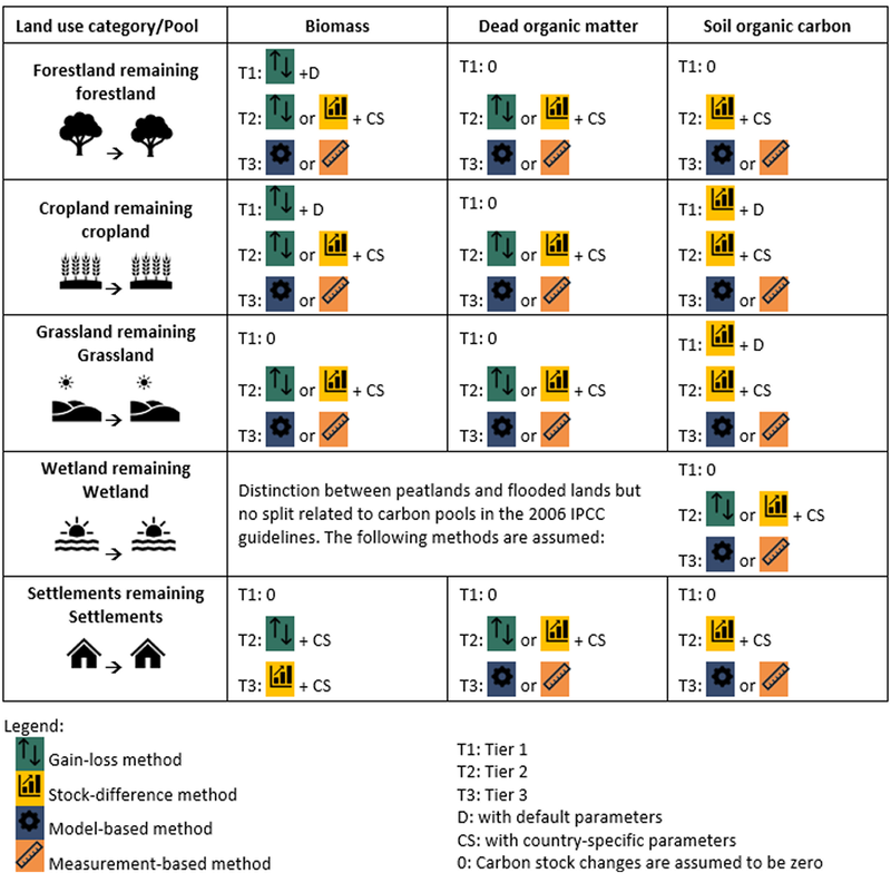
Figure 1: Example of methods by Tier level, land use and pool
What does the LULUCF Regulation say?
The LULUCF Regulation requires that Member States prepare high-quality, accurate GHG inventories. From 2021, all categories shall be reported with at least Tier 1 methodologies, and Tier 2 methodologies for key .
From the 2028 GHGI submission onwards, the LULUCF Regulation requires the application of at least Tier 2 methods for all managed land categories and emission sources.
From the 2030 submission onwards, the LULUCF Regulation requires the application of Tier 3 methods for most forest land, grassland, and wetlands.
Learn more about post 2030 requirements
How to move to higher Tiers?
Moving to higher Tiers will represent a different challenge for each Member State depending on the current state of their GHG inventory. Indeed, there is a wide disparity between the use of methodologies by EU countries. The use of Tier 3 methods covers about a quarter of all reported emissions and removals and is attributed to just a handful of countries. A significant proportion of land and carbon pools is still covered by inventories using a Tier 1 methodology. Based on the state of inventories in 2025 (Chapter 2 of the EEA report Enhancing Europe's land carbon sink), the most challenging issues on Tier levels are expected for the following cases:
Emissions and removals on mineral soils
Emissions and removals on organic soils
Emissions and removals of biomass on cropland and grassland
Emissions and removals on wetlands
Emissions and removals on settlements or other lands
Non-CO2 emissions
Emissions from biomass burning
Use of models
How to ensure time-series consistency when moving to higher Tiers?
A common worry when moving to higher Tiers is to ensure time-series consistency. Chapter 5 of Volume 1 of the IPCC Guidelines provides a list of pragmatic techniques and concrete examples on how to ensure time-series consistency, including overlapping, use of surrogate data, interpolation, trend extrapolation, and non-linear trend analysis. It also leaves room for "other techniques" when none of the techniques above can be satisfactory implemented.
A calibration approach is describes in the case study "Combination of data and a simple model to increase time resolution in the French inventory" for France, where data with high accuracy but low temporal resolution (forest inventories) and data with high temporal resolution but lower accuracy (harvest statistics) are combined.
Related case study
As many countries, France has an efficient forest inventory which provides accurate estimates of tree growth, harvest and mortality. The associated drawback is a coarse time resolution which hinders appropriation of the reported data by policy makers. To bridge this gap, a simple model combining 5-yearly forest inventory data with annual statistics was developed , allowing meaningful annual estimates which, among others, reflect dramatic events such as storms in the time series.