All official European Union website addresses are in the europa.eu domain.
See all EU institutions and bodiesAn official website of the European Union | How do you know?
Environmental information systems
EN
- БългарскиBG
- češtinaCS
- HrvatskiHR
- danskDA
- NederlandsNL
- ελληνικάEL
- EnglishEN
- eestiET
- SuomiFI
- FrançaisFR
- DeutschDE
- magyarHU
- ÍslenskaIS
- italianoIT
- LatviešuLV
- lietuviųLT
- MaltiMT
- NorskNO
- polskiPL
- PortuguêsPT
- RomânăRO
- slovenčinaSK
- SlovenščinaSL
- EspañolES
- SvenskaSV
- TürkçeTR
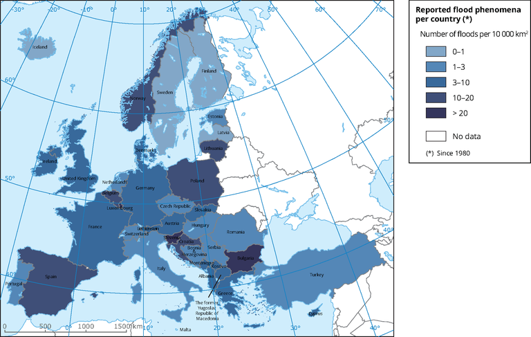
Reported flood phenomena per country
Map (static)
Number of floods per 10 000 km2 per country.
Downloads
Data sources
Metadata
More info
Loading
, Albania, Bosnia and Herzegovina, Kosovo (UNSCR 1244/99), North Macedonia, Montenegro, Norway, Serbia, Switzerland, Turkey
1980-2015
Methodology
In the first step country areas (dataset CNTR_RG_01M_2010) have been calculated within ESRI environment. From the European past floods database, table aggregated on country level has been derived together with the attribute "Number_FP" (Number of flood phenomena per country). Table was joined with the country border layer (CNTR_RG_01M_2010) (cntr_id=cc) and exported as a new layer. New field ("FP_10000" - Number of floods per 10 000 km2) has been created, values of the field have been calculated using formula Number_FP/Area_km2*10000. Values in the newly created field are classified in 5 classes (as visualized on the map).