All official European Union website addresses are in the europa.eu domain.
See all EU institutions and bodies
An official website of the European Union | How do you know?
Environmental information systems
EN

- БългарскиBG
- češtinaCS
- HrvatskiHR
- danskDA
- NederlandsNL
- ελληνικάEL
- EnglishEN
- eestiET
- SuomiFI
- FrançaisFR
- DeutschDE
- magyarHU
- ÍslenskaIS
- italianoIT
- LatviešuLV
- lietuviųLT
- MaltiMT
- NorskNO
- polskiPL
- PortuguêsPT
- RomânăRO
- slovenčinaSK
- SlovenščinaSL
- EspañolES
- SvenskaSV
- TürkçeTR

Nutrient levels in European seas, 2012 - 2017
Map (static)
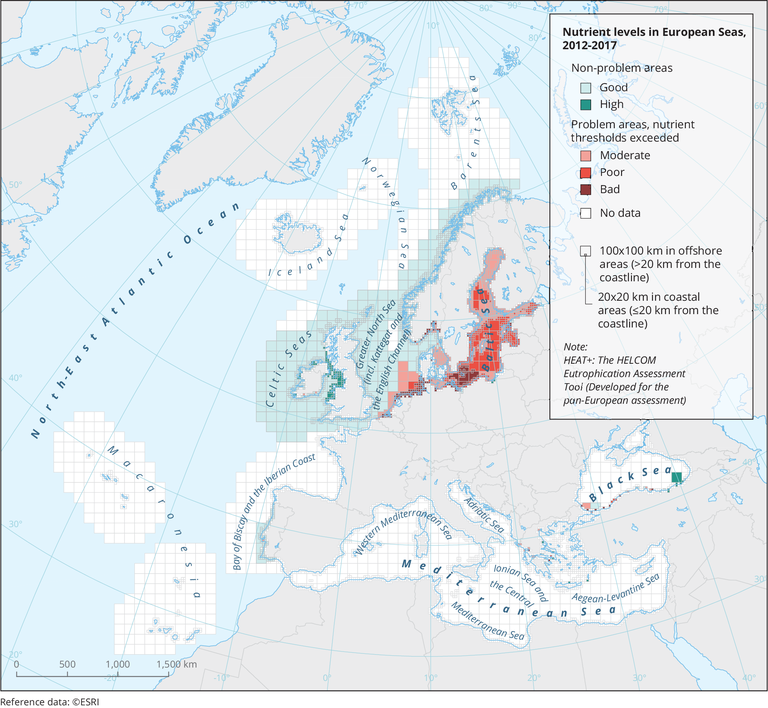
Mapping of spatial variations in the classifications of ‘nutrient levels’ based on available monitoring data, threshold values and the Heat+ assessment. Heat+ is the HELCOM Eutrophication Assessment Tool.
Downloads
Data sources
Metadata
More info
Loading
Adriatic Sea, Aegean Sea, Baltic Sea, Barentsz Sea, Black Sea, Celtic Sea, Ionian Sea, Mediterranean Sea, North Atlantic Ocean, Norwegian Sea
2012-2017