All official European Union website addresses are in the europa.eu domain.
See all EU institutions and bodies
An official website of the European Union | How do you know?
Environmental information systems
EN

- БългарскиBG
- češtinaCS
- HrvatskiHR
- danskDA
- NederlandsNL
- ελληνικάEL
- EnglishEN
- eestiET
- SuomiFI
- FrançaisFR
- DeutschDE
- magyarHU
- ÍslenskaIS
- italianoIT
- LatviešuLV
- lietuviųLT
- MaltiMT
- NorskNO
- polskiPL
- PortuguêsPT
- RomânăRO
- slovenčinaSK
- SlovenščinaSL
- EspañolES
- SvenskaSV
- TürkçeTR
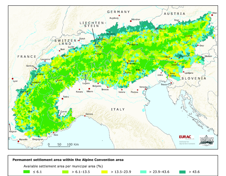
Permanent settlement area within the Alpine Convention area
Map (static)
Available settlement area at level of municipalities
Downloads
Data sources
Metadata
More info
Loading
- Data for the delination of municipalities: EuroGeographics (2005): Seamless Administrative Boundaries of Europe (SABE2004 v1.0).
- Based on Corine Landcover data 2000 the available settlement area is processed from the area for settlements from European Environment Agency (2005): Corine land cover 2000 (CLC2000) 100 m.
Data for intensively used agricultural areas are derived from national statistics as:
- AT Statistik Austria (1999): Agrarstrukturerhebung.
- CH Bundesamt für Statistik (1992-1997): Arealstatistik.
- DE Bayerisches Landesamt für Statistik und Datenverarbeitung (2001): Allgemeine Agrarstrukturerhebung.
- FR Agreste (2000): Recensement agricole; special analysis.
- IT ISTAT (2000): Censimento generale dell'agricoltura.
- LI Amt für Volkswirtschaft (2000): Landwirtschaftliche Betriebszählung.
- SI Statistični urad Republike Slovenije (2000): Popis kmetijstva.