next
previous
items

Figure

State of assessed commercial fish and shellfish stocks in relation to the good environmental status criteria for fishing mortality and reproductive capacity in marine regions

Figure Created 30 Nov 2023 Published 18 Jan 2024 Last modified 18 Jan 2024
2 min read
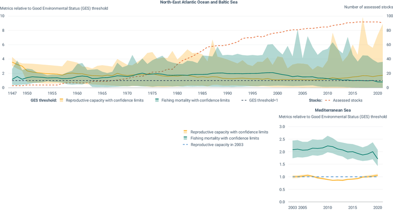
This figure shows trends in the status of assessed commercially exploited fish and shellfish stocks between 1947 and 2021, expressed in two metrics-fishing mortality (F) and reproductive capacity (i.e. spawning stock biomass (SSB))-relative to their policy thresholds for the Marine Strategy Framework Directive's 'good environmental status' (GES) (i.e. FMSY and MSY Btrigger, respectively).

European data

Metadata

Additional information

• For fishing mortality, a value greater than 1 indicates that exploitation exceeds the level that would produce the maximum sustainable yield (F>FMSY) and likely, less sustainable in the long term.
• In the North-East Atlantic Ocea and Baltic Sea, for reproductive capacity a value greater than 1 indicates that the stocks are in a healthy condition (SSB>MSY Btrigger).
• In the Mediterranean Sea, no GES threshold is available for reproductive capacity. The dashed horizontal line represents the 2003 level for this region.
• Stocks assessments have different starting years depending on the data available. In recent years the trend is based on more stocks and the trends in indicators are expected to be robust.
• Due to the reduced number of stock assessments available for the Black Sea, the indicators are not shown for this region.
• Shaded areas represent confidence limits.

GES=good environmental status; MSY=maximum sustainable yield; F=fishing mortality; FMSY=the fishing mortality that will lead to MSY catch in the long term; SSB=spawning stock biomass (a measure of reproductive capacity); MSY Btrigger=either the biomass at the lower level of the range (5th percentile) of SSB able to produce MSY or Bpa (a stock status reference point above which the stock is considered to have full reproductive capacity, having accounted for estimation uncertainty).

Geographical coverage
MSFD regions: North-East Atlantic Ocean, Baltic Sea and Mediterranean Sea

Temporal coverage
1947-2021 (Baltic and North-East Atlantic Ocean); 2003-2020 (Mediterranean Sea)


Document Actions