All official European Union website addresses are in the europa.eu domain.
See all EU institutions and bodies
- БългарскиBG
- češtinaCS
- HrvatskiHR
- danskDA
- NederlandsNL
- ελληνικάEL
- EnglishEN
- eestiET
- SuomiFI
- FrançaisFR
- DeutschDE
- magyarHU
- ÍslenskaIS
- italianoIT
- LatviešuLV
- lietuviųLT
- MaltiMT
- NorskNO
- polskiPL
- PortuguêsPT
- RomânăRO
- slovenčinaSK
- SlovenščinaSL
- EspañolES
- SvenskaSV
- TürkçeTR
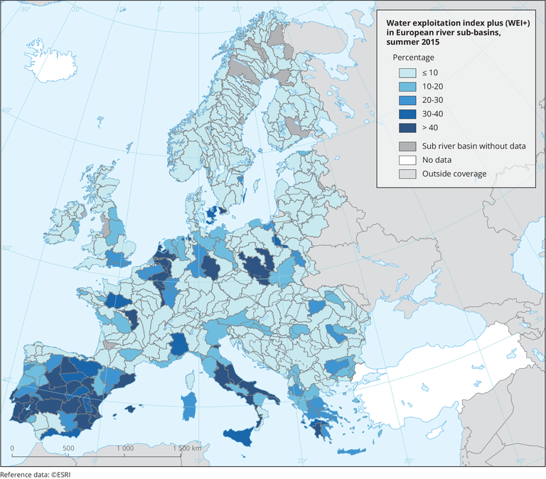
Water exploitation index plus (WEI+) in European river sub-basins, summer 2015
Map (static)
WEI+ illustrates the percentage of water use versus water available in the respective subbasin

Assessments of the sustainability of water abstraction at the European level remain limited by data availability and the approach to the interpretation of water returns. This may lead to large differences in the European WEI compared with national data sets. An example of this occurs in the south-western sub-basin of France along the Atlantic coast, an important maize production area. There, the national estimate of the WEI is around 50% because it assumes no water returns from agriculture, whereas the European estimate, which is based on a 31% returns ratio from agriculture, is below 10%.
- LISFLOOD. Distributed Water Balance and Flood Simulation Model (Dataset URL is not available)
- E-OBS gridded dataset
- Albania
- Austria
- Belgium
- Bosnia and Herzegovina
- Bulgaria
- Croatia
- Cyprus
- Czechia
- Denmark
- Estonia
- Finland
- France
- Germany
- Greece
- Hungary
- Iceland
- Ireland
- Italy
- Kosovo
- Latvia
- Liechtenstein
- Lithuania
- Luxembourg
- Malta
- Montenegro
- Netherlands
- North Macedonia
- Norway
- Poland
- Portugal
- Romania
- Serbia
- Slovakia
- Slovenia
- Spain
- Sweden
- Switzerland
- Turkey
- United Kingdom
Additional information
Assessments of the sustainability of water abstraction at the European level remain limited by data availability and the approach to the interpretation of water returns. This may lead to large differences in the European WEI compared with national data sets. An example of this occurs in the south-western sub-basin of France along the Atlantic coast, an important maize production area. There, the national estimate of the WEI is around 50% because it assumes no water returns from agriculture, whereas the European estimate, which is based on a 31% returns ratio from agriculture, is below 10%.
