All official European Union website addresses are in the europa.eu domain.
See all EU institutions and bodies
An official website of the European Union | How do you know?
Environmental information systems
EN

- БългарскиBG
- češtinaCS
- HrvatskiHR
- danskDA
- NederlandsNL
- ελληνικάEL
- EnglishEN
- eestiET
- SuomiFI
- FrançaisFR
- DeutschDE
- magyarHU
- ÍslenskaIS
- italianoIT
- LatviešuLV
- lietuviųLT
- MaltiMT
- NorskNO
- polskiPL
- PortuguêsPT
- RomânăRO
- slovenčinaSK
- SlovenščinaSL
- EspañolES
- SvenskaSV
- TürkçeTR
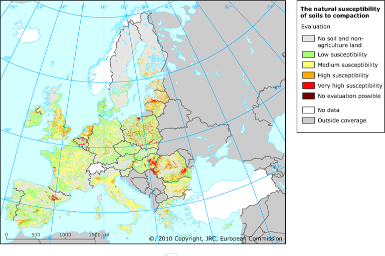
The natural susceptibility for soils to compaction
Map (static)
The map shows the natural soil susceptibility to compaction
Downloads
Data sources
Metadata
More info
Loading
- Austria
- Belgium
- Bulgaria
- Cyprus
- Czechia
- Denmark
- Estonia
- Finland
- France
- Germany
- Greece
- Hungary
- Ireland
- Italy
- Latvia
- Lithuania
- Luxembourg
- Malta
- Netherlands
- Poland
- Portugal
- Romania
- Slovakia
- Slovenia
- Spain
- Sweden
- United Kingdom
2000
Additional information
The map of natural soil susceptibility to compaction was created from the evaluation of selected parameters from the ESDB. The soil susceptibility to compaction was divided into 4 categories. Two additional categories represent the data concerning places where this evaluation was either not relevant or could not been provided because of lack of information. In total there are 6 categories:
0 - no soil. This represents water bodies, glaciers and rock outcrops
1 - low susceptibility to compaction
2. - medium susceptibility to compaction
3. - high susceptibility to compaction
4. - very high susceptibility to compaction
9. - no evaluation possible. This was the case of towns including also soils, soils disturbed by man and marsh.