All official European Union website addresses are in the europa.eu domain.
See all EU institutions and bodiesAn official website of the European Union | How do you know?
Environmental information systems
EN
- БългарскиBG
- češtinaCS
- HrvatskiHR
- danskDA
- NederlandsNL
- ελληνικάEL
- EnglishEN
- eestiET
- SuomiFI
- FrançaisFR
- DeutschDE
- magyarHU
- ÍslenskaIS
- italianoIT
- LatviešuLV
- lietuviųLT
- MaltiMT
- NorskNO
- polskiPL
- PortuguêsPT
- RomânăRO
- slovenčinaSK
- SlovenščinaSL
- EspañolES
- SvenskaSV
- TürkçeTR
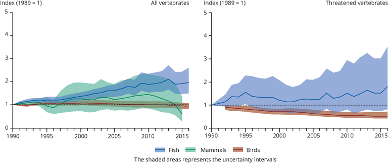
Living Planet Index calculated for main marine vertebrate groups
Chart (static)
The Living Planet Index (LPI) is used for a number of biodiversity indicators, based on geometric averaging.
Downloads
Data sources
Metadata
More info
Loading
- Living Planet Index (Dataset URL is not available)
Adriatic Sea, Aegean Sea, Baltic Sea, Bay of Biscay, Black Sea, Eastern Mediterranean, English Channel, Ionian Sea, Kattegat, Levantine Sea, Mediterranean Sea, North Sea, Norwegian Sea, Tyrrhenian Sea, Western Mediterranean
1990-2016
Methodology
The Living Planet Index (LPI) is used for a number of biodiversity indicators, based on geometric averaging, using a GAM procedure (method explained and code provided here: https://github.com/Zoological-Society-of-London/rlpi).
Data was compiled from open access data sources by European Topic Centre (Inland, Coastal & Marine)