All official European Union website addresses are in the europa.eu domain.
See all EU institutions and bodiesAn official website of the European Union | How do you know?
Environmental information systems
EN
- БългарскиBG
- češtinaCS
- HrvatskiHR
- danskDA
- NederlandsNL
- ελληνικάEL
- EnglishEN
- eestiET
- SuomiFI
- FrançaisFR
- DeutschDE
- magyarHU
- ÍslenskaIS
- italianoIT
- LatviešuLV
- lietuviųLT
- MaltiMT
- NorskNO
- polskiPL
- PortuguêsPT
- RomânăRO
- slovenčinaSK
- SlovenščinaSL
- EspañolES
- SvenskaSV
- TürkçeTR
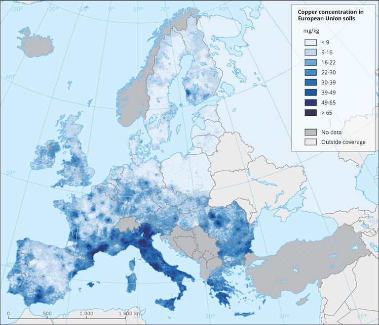
Copper concentration in European Union soils
Map (static)
Map of Copper concentrations in European Union agricultural top soils (upper 20 cm).
Downloads
Data sources
Metadata
More info
Loading
- LUCAS Soil, the largest expandable soil dataset for Europe: a review (Dataset URL is not available)
- Potential Sources of Anthropogenic Copper Inputs to European Agricultural Soils (Dataset URL is not available)
- Copper distribution in European topsoils: An assessment based on LUCAS soil survey (Dataset URL is not available)
, Bulgaria, Czechia, Estonia, Hungary, Latvia, Lithuania, Poland, Romania, Slovakia, Slovenia
2010
Methodology
Copper (Cu) distribution in soil is influenced by climatic, geological and pedological factors. Apart from geological sources and industrial pollution, other anthropogenic sources, related to the agricultural activity, may increase copper levels in soils, especially in permanent crops such as olive groves and vineyards. This study uses 21,682 soil samples from the LUCAS topsoil survey to investigate copper distribution in the soils of 25 European Union (EU) Member States.Generalized Linear Models (GLM) were used to investigate the factors driving copper distribution in EU soils. Regression analysis shows the importance of topsoil properties, land cover and climate in estimating Cu concentration. Meanwhile, a copper regression model confirms our hypothesis that different agricultural management practices have a relevant influence on Cu concentration. Besides the traditional use of copper as a fungicide for treatments in several permanent crops, the combined effect of soil properties such as high pH, soil organic carbon and clay, with humid and wet climatic conditions favours copper accumulation in soils of vineyards and tree crops.
Additional information
Input data: GEMAS (Reiman et al. 2013); Eurostat 2010
- The data provided has been prepared for use by internal research activities in European Soil Data Centre (Sustainable Resources Directorate, JRC Ispra) in the context of developing the assessments of diffuse pollution and as a contribution to soil threats in Europe (RECARE project).
- The data were developed for research purposes of the JRC (European Commission). The JRC does not accept any liability whatsoever for any error, missing data or omission in the data, or for any loss or damage arising from its use. The JRC agrees to provide the data free of charge but is not bound to justify the content and values contained in the databases.
- The data/maps are result of interpolation (and advanced geostatistics) and they should be used with care. It is not recommended to use this dataset for qualifying the status of a point (parcel).