All official European Union website addresses are in the europa.eu domain.
See all EU institutions and bodies
An official website of the European Union | How do you know?
Environmental information systems
EN


Discover the CLCplus LULUCF Instance, produced by the Copernicus Land Monitoring Service, CLMS — a geospatial product designed to support greenhouse gas reporting and other LULUCF applications across the EEA38 area.

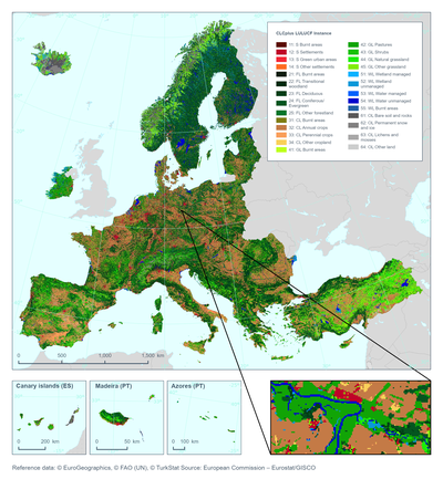
CLCplus LULUCF Instance. Annual geospatial LULUCF activity data proxy at 100m spatial resolution.
Annual products from 2021, spatial coverage EEA38 (until 2023) then EEA38+UK
Part of the CLCplus product suite is the CLCplus Core online database and operational application. CLCplus Core allows users to derive tailor-made land cover and land use products (so called "Instances") at 100 m spatial resolution.
The annual LULUCF instance dataset provides a harmonised, pan-European proxy for the 6 main LULUCF categories, as well as several sub-categories. It uses all available operational pan-European CLMS and other geospatial datasets on land use and land cover elements that are relevant for LULUCF. It attempts to map, for the whole area of EEA38+UK, the geospatial representation of the LULUCF categories as reported annually by the (EU) countries.
The LULUCF Instance is available for 2018, and then annually from 2021. The product is covering the entire EEA38 area and will likely include the UK for 2024 and later annual products. Its creation is embedded in the CLCplus Core system and relies on thorough knowledge of the input datasets, their respective land cover and land use class definitions, their timeliness, and their data availability.
The LULUCF Instance is the only available consistent pan-European geospatial proxy dataset for LULUCF categories. The main use-idea is to support countries in establishing their own national geospatial LULUCF systems and to support EEA in Verification efforts for the country-reported data. Major discrepancies between country reported area estimates for LULUCF categories with those derived from the LULUCF instance will be followed up with the respective country. The aim is to explore reasons for the discrepancies in a constructive and supportive spirit, and to encourage and support possible improvements in monitoring and reporting on the side of countries. Existing valuable data and feedback from countries will also be used to improve CLMS products and future iterations of the LULUCF instance.
Important notice to users
It is crucial to understand that this product is fundamentally different from all other CLMS products, in that it is not based directly on Satellite image classification/interpretation but is produced by combining existing CLMS data layers. Instead it leverages the optimal combination of the latest available CLMS products to deliver added value beyond stand-alone products.
Users should also consider and understand that the input data available to reliably reproduce all 6 main LULUCF categories (and sub-categories) differs significantly in terms of availability, update frequency and match to the target classes. For example, as one of the target classes, the product attempts to approximate the LULUCF wetland category, but without a dedicated operational CLMS wetland product. This means that users need to be aware that the annual wetland class of the LULUCF instance does not mean that CLMS is now annually mapping wetlands, but instead combines available proxy data.
Please find a frequently updated and more detailed description of the available data, links to data download and visualisation, and additional documentation (such as a product user manual, and extraction rules) on the CLMS portal https://land.copernicus.eu/en/products/clcplus-lulucf-instance
More information on the datasets is also available via the EEA geospatial data catalogue here EEA geospatial data catalogue