next
previous
items

Figure

Spread of artificial and/or agricultural surfaces into previously ‘core natural/semi-natural’ landscapes

Figure Created 13 Feb 2015 Published 01 Dec 2015 Last modified 28 Mar 2022
2 min read
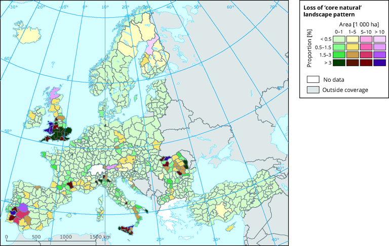
The map shows the spread of artificial and/or agricultural surfaces into previously ‘core natural/semi-natural’ landscapes for the period 2000-2006. Reporting is made per province (NUTS 2/3), both in terms of absolute area (ha) and proportionally to the ‘core natural’ pattern cover in 2000. For example, one province in the West of Spain had its ‘core natural’ pattern reduced by 1.5% to 3% due to fragmentation by agricultural and/or artificial lands, from a cumulative area of more than 10 000 ha.

Metadata

Additional information

How to read the map: in the period 2000-2006, the spread of artificial and/or agricultural surfaces into previously ‘core natural/semi-natural’ landscapes is reported per province (NUTS 2/3) both in terms of absolute area (ha) and proportionally to the ‘core natural’ pattern cover at year 2000. For example, one province in the West of Spain had its ‘core natural’ pattern reduced by 1.5% to 3% due to fragmentation by agricultural and/or artificial lands of a cumulative area of more than 10 000 ha.

Source: European Commission-Joint Research Centre (JRC); Estreguil and Caudullo, 2014

Estreguil, C., Caudullo, G., 2014. Fragmentation of natural/semi-natural landscapes in Europe. JRC scientific and policy report EUR xxEN. JRC Pubsy request nb 92408. Luxembourg: Publications Office of the European Union. doi: (in preparation).

Permalinks

Geographic coverage

Temporal coverage