All official European Union website addresses are in the europa.eu domain.
See all EU institutions and bodiesAn official website of the European Union | How do you know?
Environmental information systems
EN
- БългарскиBG
- češtinaCS
- HrvatskiHR
- danskDA
- NederlandsNL
- ελληνικάEL
- EnglishEN
- eestiET
- SuomiFI
- FrançaisFR
- DeutschDE
- magyarHU
- ÍslenskaIS
- italianoIT
- LatviešuLV
- lietuviųLT
- MaltiMT
- NorskNO
- polskiPL
- PortuguêsPT
- RomânăRO
- slovenčinaSK
- SlovenščinaSL
- EspañolES
- SvenskaSV
- TürkçeTR
Examples of the use of effective mesh density in monitoring systems of sustainable development, biodiversity, and landscape quality
Chart (static)
-
Downloads
Data sources
Metadata
More info
Loading
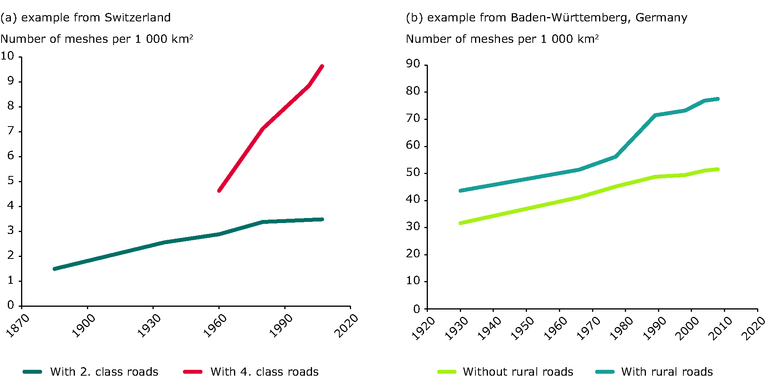
(a) Switzerland: the data are used in the Swiss Landscape Monitoring System (LABES), in the Biodiversity Monitoring
Switzerland, and in the Swiss Monitoring System of Sustainable Development (MONET). Two fragmentation geometries are
shown: 'CH-1: Degree of Fragmentation class 2' (shown in blue) includes land areas below 2 100 m with roads up to class 2,
and 'CH-2: Degree of Fragmentation class 4' (shown in red) with roads up to class 4 for 1960–2008.
Note that 'Degree of Fragmentation class 2' also includes values for 1885 and 1935 which are based on a different dataset.
(b) Baden-Württemberg: times series since 1930 for two fragmentation geometries: with and without municipal roads. The
values in Switzerland are for the entire country, including the Jura mountains and parts of the Alps up to 2 100 m. Therefore, they are much lower than the values in Baden-Württemberg. However, the level of fragmentation in the Swiss Lowlands is much higher than the average and similar to the values in Baden-Württemberg