4. DISCUSSION
4.1 Geographic coverage of monitoring stations
For 1996 information from 836 stations was received; for nearly all of
them geographical coordinates are available. For the interpretation of ozone data it is
essential to have an indication of the direct surroundings of the station as the ozone
concentration may be strongly influenced by local conditions. For example, the ozone
concentrations may be scavenged by locally emitted nitrogen oxides or by enhanced dry
deposition as might be the case under a forest canopy; see Annex
II for a brief discussion on ozone phenomenology. For nearly all stations information
on immediate surroundings is available.
Based on the information submitted on station type and characteristics,
Figure 3 shows the partitioning between background (or rural), urban, street and other
stations in each of the Member States. Within the European Union the station
classification varies strongly: from only rural stations (Sweden) to about 50% urban
stations (Denmark, Greece, Germany). A relatively large number of street stations is
located in Luxembourg and Spain. There are, however, clear indications that the
classification of stations is not uniform over the Member States. Based on the
phenomenology of ozone (see Annex II) one expects that ozone
concentrations should cluster at low (street), medium (urban) and high levels (rural); the
corresponding NOx concentrations should cluster in reversed order. Although
this tendency is shown (see Figure 4), there is a considerable overlap between the sets of
stations. Information on NOx concentrations will be helpful to validate the
station classification. For a limited number of stations (7 Member States, 73 stations)
both NOx and ozone statistics are submitted. Figure 4 shows the relation
between the yearly average NOx and the ozone 50-percentile value. The
clustering in stations is noted here; this type of graph could guide further harmonisation
on classification. Further work on classification of station is being undertaken by ETC-AQ
in co-operation with DGXI of the European Commission.
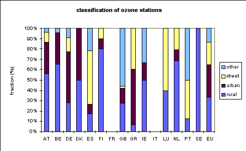
Figure 3. Classification of ozone stations according to their direct
surroundings as rural, urban, or street station; 'other' indicates both other station
types (e.g. in industrial areas) and stations for which no information of station type is
available.
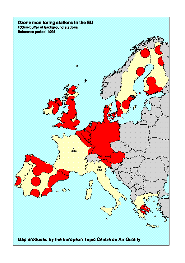
Map 2 shows the location of background monitoring stations. Tentatively,
the area for which the measurements at these stations are assumed to be representative is
indicated with a circle using a radius of 100 km. This "radius of
representativeness" might be different for the various regions in Europe - it might
even depend on the wind direction - and should be based on more detailed analysis of the
ozone phenomenology at the stations. Although the identification of the background
stations is far from complete and the radius of representativeness may differ from the
assumed 100 km, Map 2 suggests that the present set of stations covers 40 to 50% of the
land area of the EU. As is shown in Map 2 the geographical coverage of background stations
is rather adequate in North-West Europe but in other regions (e.g. Greece) gaps are noted;
data for France and Italy are lacking but based on the information received for 1995 (de
Leeuw and van Zantvoort, 1996), it is assumed that coverage by background stations is
inadequate.
It has been attempted to quantify the coverage of the monitoring
stations for urban areas as is relevant for population exposure. According to information
obtained from the Eurostat population database, there are in the EU about 2000 cities with
more than 25 000 inhabitants. It is estimated that from a total EU population of about 362
million, about 195 million people live in these cities with more than 25 000
inhabitants. Summation of the number of inhabitants of all the cities in which at least one ozone station is operational
and has been reported to the EC in 1996, leads to a total of approximately 65 million.
Hence for only 32% of the total urban population (equivalent to 18% of the total EU
population) can an estimate of ozone exposure be made.
Although the uncertainties in the classification of the present set of
stations (e.g. the representative radius for the urban and street stations is unknown)
preclude any firm conclusion, it is clear that the set of urban stations in the national
networks is not representative for the total urban population in the EU. Conclusions
concerning the exposure of urban population to high ozone levels should therefore be seen
as tentative.
Figure 4. Relation between yearly average NOx
concentration and ozone 50 percentile values at a limited number of stations ( period 1
January -31 December 1996).
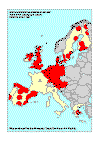
Map 2. Location of background ozone monitoring stations. Tentatively
the area for which the ozone measurements might be representative is indicated with a
circle with a radius of 100 km.
4.2 Annual statistics, 1996
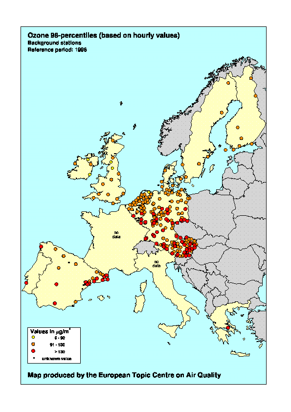
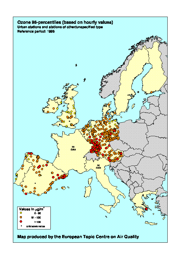
The geographical distribution of 98-percentile values calculated on the
basis of hourly concentrations is presented in Map 3 for background stations and in Map 4
for urban, street and other stations.
Similar to the observations in previous years (de Leeuw et al.,
1995; de Leeuw and van Zantvoort, 1996) the 98-percentiles at background stations
show in general low values in the Scandinavian countries, and an increase from North-West
to Central Europe. In particular for the stations in Austria, the elevated location of the
monitoring stations may play a role. Similar patterns have been estimated from
measurements made within the framework of EMEP (Hjellbrekke, 1996). However, the
relatively low values observed in the EMEP data over the Iberian peninsula are not in
agreement with the present observations which might be caused by differences in year, in
averaging period and in the set of reporting stations.
For urban and 'other' stations (Map 4) no large scale concentration
gradient in 98-percentiles is recognized; high values are observed all over the continent.
The local conditions (at stations downwind of the urban area relatively high ozone values
might be observed whereas at stations with NOx sources, such as traffic, in
their immediate surrounding relatively low ozone levels will be measured, see Figure 4 and
Annex II) appears to be more important than European-wide smog episodes.
The 98-percentile values based on moving eight-hourly average
concentrations show a strong correlation with the hourly 98-percentile: on average, 8-h
percentiles are about 7 µg/m3 lower than the corresponding 1h value.
However, this relation depends on the type of the stations, see Figure 5; a comparison
with previous years also shows that the ratio of 1h and 8h 98-percentile values has a
meteorological dependence. The overlap between the ranges spanned by the observations at
the three classes of stations suggests that the classification scheme needs further
harmonisation. The geographical distribution of the 8-h percentile values is very similar
to the distribution of the 1-h percentile values.
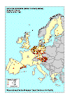
Map 3. 98 percentiles (based on hourly concentrations; µg/m3) measured at
background stations, period 1 January-31 December 1996.
Map 4. 98 percentiles (based on hourly concentrations; µg/m3)
measured at urban, street and other stations, period 1 January-31 December 1996.
Figure 5. Relation between 98-percentiles values based on hourly
concentrations and 8-hourly concentration at all reporting stations (in µg/m3;
1 January-31 December 1996).
4.3 Exceedances of thresholds in 1996
4.3.1 Exceedances of the threshold value for protection of
human health
The threshold value for protection of human health (110 µg/m3)
is based on eight-hourly values. According to the Ozone Directive, four eight-hourly
periods have to be considered: 0.00-8.00; 8.00-16.00, 16.00-24.00 and 12.00-20.00. Based
on the average diurnal profile of ozone (see Annex II) the highest eight-hourly values are
generally expected for the 12.00-20.00 period; only exceedances of the threshold values
for this period have been considered here.
No clear definition of the time reference (local time or universal time,
summer- or winter time) is given. This might lead to inconsistencies between the Member
States. The differences between the maximum concentrations quoted for the 8-h
concentration between 12.00 and 20.00 (Table 3) and for the moving 8-h average
concentrations (Table 6) indicates that small errors might be introduced by the ambiguity
on time reference.
In 1996 exceedances of this threshold value have been observed in all
reporting countries. In five Member States maximum concentrations exceeding twice the
threshold value have been observed (see Table 3).
|
AT |
BE |
DE |
DK |
ES |
FI |
FR |
GB |
GR |
IE |
IT |
LU |
NL |
PT |
SE |
| #ex |
3873 |
396 |
8721 |
73 |
4114 |
157 |
na |
403 |
664 |
25 |
na |
149 |
455 |
129 |
111 |
| #st |
111 |
23 |
368 |
6 |
182 |
9 |
na |
49 |
11 |
6 |
na |
5 |
38 |
7 |
6 |
n.a = number of exceedances not available
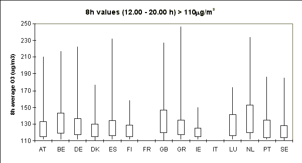
Figure 6. Frequency distribution of ozone concentrations
(eight-hourly values; period 12.00-20.00;
1 January - 31 December 1996) in excess of the 110 µg/m3 threshold
for hourly values. For each country the total number of observed exceedances is given in
row '#Ex', the number of stations is given in row '#St'. Frequency distributions are
presented as Box-Jenkins plots indicating the minimum, the 25-Percentile, the
75-percentile and the maximum value.
Figure 6 shows the frequency distribution of eight-hourly ozone
concentrations in excess of the threshold value using so-called Box-Jenkins plots. For
each Member State the Box-Jenkins plot indicates the minimum (here the minimum is of
course 110 µg/m3), the maximum, the 25 percentile and the 75 percentile value
of the concentrations during exceedance. Although extreme peaks of more than 200 µg/m3
are observed in seven out of 13 reporting Member States, Figure 6 shows that, in each
Member State, less than 25% of all exceedance concentrations are above 165 µg/m3
(that is, above 150% of the threshold value).
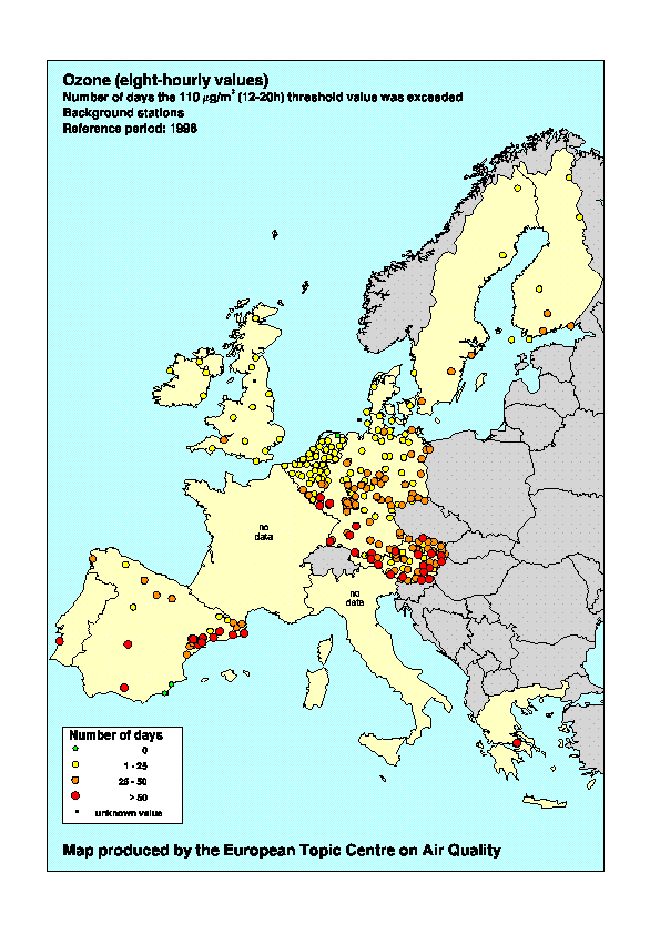
The geographical distribution of the number of days the threshold value
was exceeded is shown in Map 5 for background stations and in Map 6 for urban, street and
other stations. A comparison of Map 5 and 6 shows that exceedances are more frequently
observed at rural stations. This is also demonstrated more clearly in Figure 7 where for
each station type (rural, urban and street stations) the average number of exceedances is
plotted. The average occurrence of exceedances generally decreases in the order rural -
urban - street. Note that 'other' stations and stations for which the type has not been
specified have been excluded from Figure 7.
Of the total EU urban population, about 65.5 million people live in
cities with one or more ozone monitoring stations reporting in the framework of the Ozone
Directive. The number of days on which this population is exposed to ozone levels
exceeding the 110 µg/m3 threshold values ranges from zero days (for 12% of the
population, see Figure 8) to more than 50 days (for 6% of the population). The majority
(72%) of city dwellers in 1996 is exposed to ozone levels exceeding 110 µg/m3
during 1-25 days.
These results should be interpreted with great care. The observations at
the present set of urban stations might not be representative for the total urban
population; only 32% of the urban population lives in a city "covered" by
an ozone monitoring station, and information on urban situation is scarce or even lacking
in some Member States (in five Member States the number of operational urban or street
monitoring stations is three or less). Although more quantitative conclusions cannot be
drawn at this stage, it is likely that a substantial fraction of the urban population is
frequently exposed to high ozone levels. Increases in mortality and in hospital admission
for chronic obstructive pulmonary diseases are to be expected (Anderson et al., 1997;
Sartor et al., 1997; Beck and Krzyzanowski, 1997).
In rural areas the number of exceedances is higher than in urban
regions, see Figure 7. It is estimated that in more than 95% of the area for which
information is available (see Map 2) the threshold value is exceeded at least on one day
in 1996. When rural population is defined as the population living in villages and
cities with less than 25,000 inhabitants, a total rural population of about 89 million
lives within the assumed radius of representativeness of 100 km around rural stations. The
fraction of the rural population which is not exposed to 8h ozone levels exceeding 110
µg/m3 is less than 2%; slightly less than half of the rural population (about
43 million people) is exposed to high ozone levels on more than 25 days. Similar to Figure
7, Figure 8 demonstrates the higher exposure of the rural population.
Exceedances most frequently occur in the summer months (May-August). In
the winter months (January-March and September-December) exceedances have been observed
very occasionally.
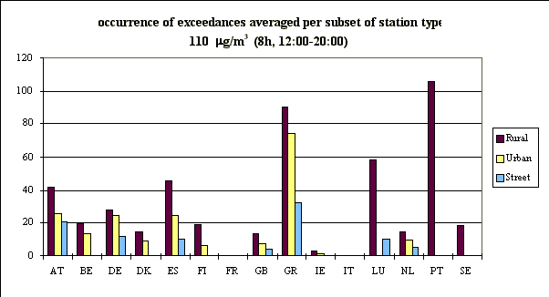
Figure 7. The occurrence of exceedances of the threshold value for
protection of human health (110 µg/m3 for eight-hourly values, period 1
January - 31 December 1996) averaged over all reporting rural, urban, and street stations.
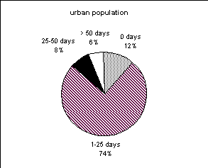
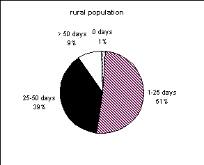
Figure 8. Number of exceedances (in days) and frequency distribution
of urban and rural population exposed to eight-hourly concentrations exceeding 110 µg/m3,
1 January-31 December 1996. Note that information on ozone exceedances which has been made
available within the framework of the ozone directive, is estimated to be representative
for a total urban population of 65.5 million (that is, about 32% of the EU population
living in cities with more than 25 000 inhabitants and 18% of the total population in the
EU) and for a total rural population of about 90 million.
Map 5. Number of exceedances of the threshold value for protection of
human health (110 µg/m3 for eight hourly values) observed at background
stations; 1 January-31 December 1996; eight-hourly average values for the period
12.00-20.00.
Map 6. Number of exceedances of the threshold value for protection of
human health (110 µg/m3 for eight-hourly values) observed at urban, street
and other stations; 1 January-31 December 1996; eight-hourly average values for the period
12.00-20.00.
4.3.2 Exceedances of the threshold values for information and
warning of the population
The threshold value for warning of the population (360 µg/m3,
hourly value) was exceeded in 1996 on 21 May at two stations in Athens, Greece: Liosia and
Marousi. This episode is an example of 'local' ozone episodes in the Mediterranean region.
Other stations in Athens or in its close vicinity reported exceedances of both the 1h -
180 µg/m3 and 8h - 110 µg/m3 threshold values on this day; no
other Member State reported an exceedance of the threshold of 180 µg/m3 for
this day.
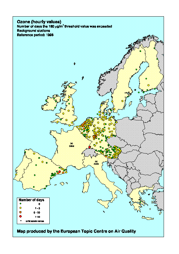
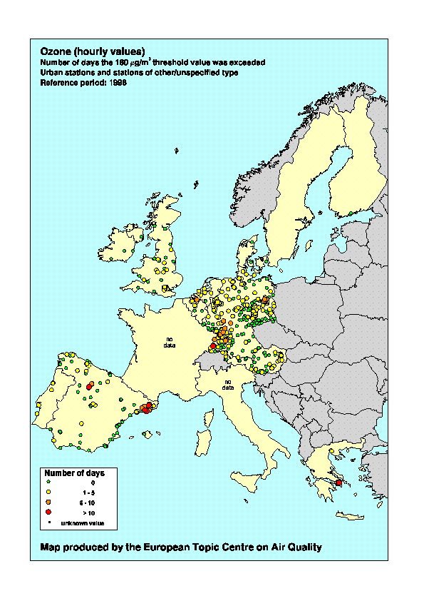
The geographical distribution of the number of exceedances of the
threshold value for information of the public (180 µg/m3, hourly value) is
presented in Map 7 for background stations and in Map 8 for urban, street and other
stations. Exceedances are reported for 12 Member States: from France and Italy information
is lacking and only in Ireland was the 180 µg/m3 level not reached. Similar to
the exceedances of the threshold values of 8-hourly average concentrations, the threshold
values for public information occur more frequently at rural stations than at urban or
street stations. For urban stations an overview of the number of exceedances weighted
according to the population of the city, is presented in Figure 9. From these limited
data, it appears likely that about 60% of the urban population and about 80% of the rural
population are exposed to ozone concentrations exceeding 180 µg/m3 for one or
more days.
Figure 10 shows the frequency distribution of concentrations in excess
of the threshold value for information. Although incidentally the threshold value may be
exceeded by more than a factor of two, in almost all of the cases the exceedances are less
extreme: Figure 10 shows that in nearly all Member States on 75% of the days on which the
threshold value was exceeded, the level of 250 µg/m3 (that is 150% of the
threshold value) was not reached.
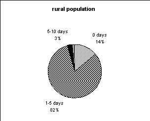
Figure 9. Number of exceedances (in days) and frequency distribution
of urban and rural population exposed to hourly ozone concentrations exceeding 180 µg/m3,
1 January-31 December 1996.
Exceedances are observed during a large part of the year, starting in
spring (22-24 April, exceedances in Germany and Austria) but occur most frequently and
geographically most widespread during the summer months. Figure 11 shows the scaled total
number of exceedances (summation of occurrence of exceedances over Member States) per day.
The most wide-spread episode was on 5-7 June (see the discussion in Sluyter and van
Zantvoort, 1996). Although in Figure 11 a correction is made for the differences in
network density in the Member States, it is still difficult to estimate the geographical
extent of an episode: a scaled value of one might imply that on all stations in one
country an exceedance is observed but it also might indicate that in 10 Member States on
10% of the stations an exceedance is observed. For example, the two days with a scaled
number of exceedances of 0.7 - 0.75 ( 8 and 22 July) have a different character: on 8 July
the episode was 'local' with more than 60% of the Greek stations having an exceedance
whereas on 22 July in six Member States a relative small number of stations showed an
exceedance.
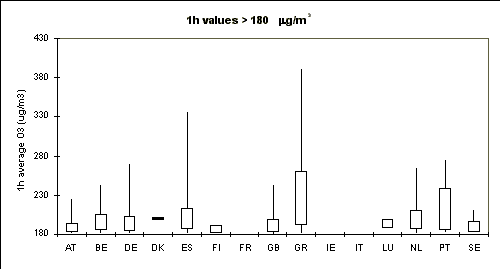
|
AT |
BE |
DE |
DK |
ES |
FI |
FR |
GB |
GR |
IE |
IT |
LU |
NL |
PT |
SE |
#ex |
94 |
37 |
613 |
1 |
212 |
2 |
na |
53 |
138 |
0 |
na |
8 |
100 |
14 |
6 |
#st |
111 |
23 |
369 |
6 |
189 |
10 |
na |
50 |
13 |
6 |
na |
5 |
38 |
8 |
6 |
Figure 10. Frequency distribution of ozone concentrations (hourly values; 1 January
- 31 December 1996) in excess of the 180 µg/m3 threshold for hourly
values. For each country the total number of observed exceedances is given in row '#Ex',
the number of stations is given in row '#St'. Frequency distributions are presented as
Box-Jenkins plots indicating the minimum, the 25-Percentile, the 75-percentile and the
maximum value.
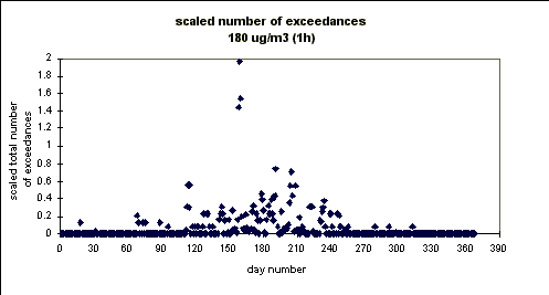
Figure 11. Scaled total number of exceedances (summation over all
Member States of the occurrence of exceedances) of the ozone threshold value for
information (180 µg/m3);
1 January - 31 December 1996.
Map 7. Number of exceedances of the threshold value for information
of the population (180 µg/m3 for hourly values) observed at background
stations;1 January-31 December 1996.
Map 8. Number of exceedances of the threshold value for information
of the population (180 µg/m3 for hourly values) observed at urban, street
and other stations; 1 January-31 December 1996.
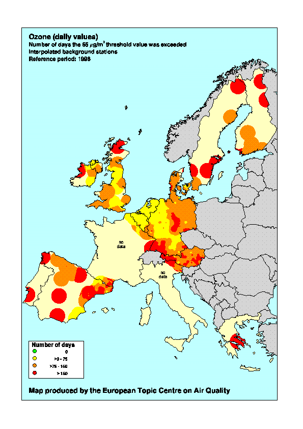
4.3.3 Exceedances of the daily threshold value for
protection of vegetation
As Table 4 shows, exceedances of the daily threshold of 65 µg/m3
were frequently observed in all reporting countries. Stations where the threshold was
exceeded on more than 100 days in 1996 are located all over the EU. The geographical
distribution of the number of exceedances of the daily threshold is presented in Map 9 for
the background stations. In Map 9 an attempt has been made to quantify the area where
exceedances are observed. For the background stations a representative radius of 100 km is
assumed, see also Map 2. When the "representative areas" of two or more stations
overlap, the number of exceedances in this location is estimated by a distance-weighted
interpolation. In a negligible part of the total area "covered" by the rural
stations (1 440 000 km2) the 65 µg/m3 level is not exceeded. In 23%
of the area the 65 µg/m3 level is exceeded on 1-75 days; in 47% of the area on
76-150 days and in 31% of the area on more than 150 days. Exceedances on more than 150
days are reported both by northern and southern Member States (see Map 9).
Figure 12 shows the exposure classes in relation to land-use data.
Assuming a 100 km representative radius the current set of rural stations is estimated to
cover about 40% of forests and about 50% of arable land on the average; within the EU-15
large differences in coverage between the Member States are observed (Beck and
Krzyzanowski, 1997). For the majority of the areas covered by the three land-use types an
exceedance on more than 75 days is observed.
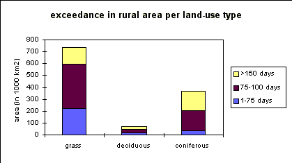
Figure 12. The occurrence of exceedances of the threshold value for
protection of vegetation (65 µg/m3 as daily value; period 1 January - 31
December 1996) averaged over all reporting rural, urban and street stations.
For exceedances of a daily average concentration, the differences
between rural and urban stations are more pronounced than is the case for hourly
concentrations. In urban areas the low concentrations during the night (caused by
interaction with NOx emissions) reduce the daily average concentrations; in
rural areas the decrease in ozone concentrations during the night is generally less
strong. In NW Europe, however, the high NOx emission density might cause also
some quenching of ozone at rural sites which explains the relatively low number of
exceedances in this region compared both to North and South Europe.
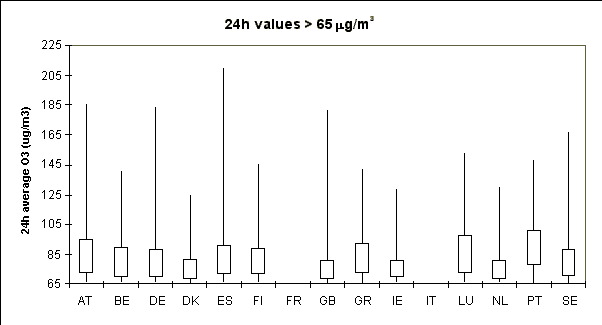
Figure 13 shows the frequency distribution of daily values in excess of
65 µg/m3. Although extreme values of more than 200 µg/m3 are
observed, in nearly all Member States for 75% of the exceedances the daily average
concentration falls between 65 and 98 µg/m3 (that is 150% of the threshold
value). Although the exceedances are most frequently observed in the period March to
September, daily values above 65 µg/m3 are observed in all reporting Member
States also during the winter months (January-February and October-December 1996).
|
AT |
BE |
DE |
DK |
ES |
FI |
FR |
GB |
GR |
IE |
IT |
LU |
NL |
PT |
SE |
| #ex |
12046 |
880 |
20748 |
528 |
13001 |
1299 |
na |
1677 |
1342 |
559 |
na |
354 |
1056 |
372 |
959 |
| #st |
111 |
23 |
369 |
6 |
181 |
10 |
na |
48 |
15 |
6 |
na |
5 |
38 |
6 |
6 |
Figure 13. Frequency distribution of ozone concentrations (24h values; 1 January -
31 December 1996) in excess of the 65 µg/m3 threshold for daily values.
For each country the total number of observed exceedances is given in row '#Ex', the
number of stations is given in row '#St'. Frequency distributions are presented as
Box-Jenkins plots indicating the minimum, the 25-Percentile, the 75-percentile and the
maximum value.
Map 9. Number of exceedances of the threshold value for vegetation (65 µg/m3
for daily values) observed at background stations; 1 January-31 December 1996. Data is
interpolated using inverse distance weighting and a cut-off distance of 100 km.
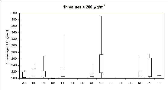
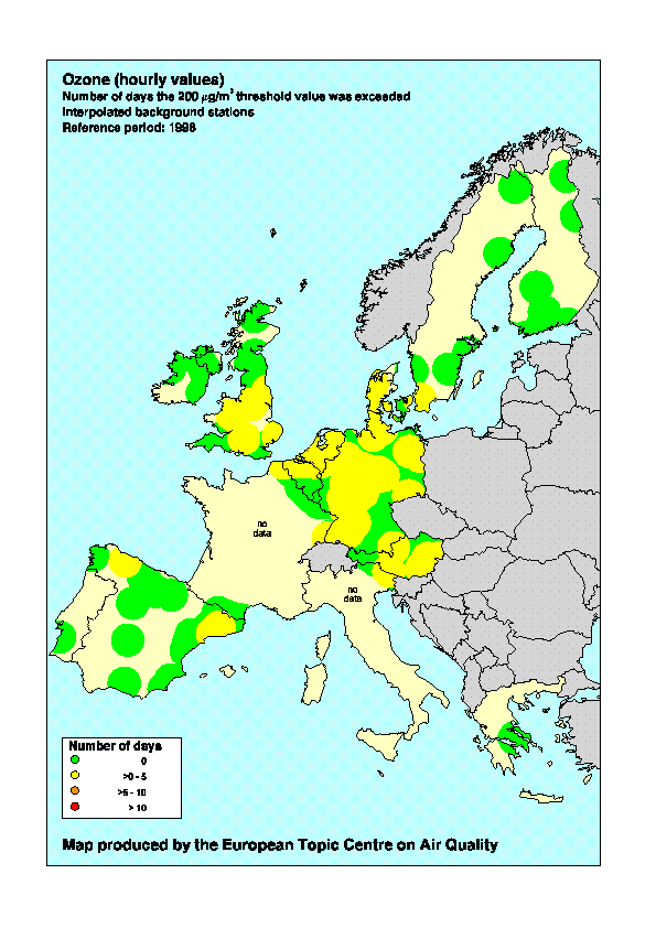
4.3.4 Exceedance of the hourly threshold value for protection
of vegetation
Exceedances of the hourly threshold values for protection of vegetation
(200 µg/m3) are reported by 10 Member States; no exceedances were observed in
Finland, Ireland and Luxembourg, see Table 4. The geographical distribution of the number
of days on which this hourly threshold value was exceeded is presented in Map 10 for
background stations. The map shows that roughly above 60° N this threshold
value was not exceeded in 1996; most frequently exceedances are observed in England,
Belgium, the Netherlands, Germany and Austria; In Luxembourg the maximum 1h concentration
was just below the 200 µg/m3 threshold level. On the Iberian Peninsula only a
limited number of exceedances has been observed.
In 56% of the rural regions where data from representative monitoring
stations is reported (see Map 2) no exceedances of the 200 µg/m3 threshold
value were observed; in 44% of the area an exceedance is observed during 1-5 days whereas
exceedances during more than 5 days were observed at one rural station only.
For the various land-use classes in 56%, 41% and 31% of the area covered by arable land,
broad-leaved forest and coniferous or mixed forest, respectively, the vegetation is
exposed to ozone concentrations above the threshold during 1-5 days. Higher number of
exceedances (up to 26 ) were observed at urban/street stations.
The frequency distribution of exceedances of the hourly threshold are
presented in Figure 14. For about 75% of the exceedances the ozone levels fall between 200
and 275 µg/m3.
|
AT |
BE |
DE |
DK |
ES |
FI |
FR |
GB |
GR |
IE |
IT |
LU |
NL |
PT |
SE |
#ex |
14 |
11 |
177 |
1 |
84 |
0 |
na |
13 |
83 |
0 |
na |
0 |
46 |
6 |
1 |
#st |
111 |
23 |
369 |
6 |
189 |
10 |
na |
50 |
11 |
6 |
na |
5 |
38 |
8 |
6 |
Figure 14. Frequency distribution of ozone concentrations (hourly values; 1 January
- 31 December 1996) in excess of the 200 µg/m3 threshold for hourly
values. For each country the total number of observed exceedances is given in row '#Ex',
the number of stations is given in row '#St'. Frequency distributions are presented as
Box-Jenkins plots indicating the minimum, the 25-Percentile, the 75-percentile and the
maximum value.
Map 10. Number of exceedances of the threshold value for vegetation (200 µg/m3
for hourly values) observed at background stations;1 January-31 December 1996. Data is
interpolated using inverse distance weighting and a cut-off distance of 100 km.
4.4 Summer smog episodes in 1996
A first analysis of the episodes during summer 1996 has been presented
by the ETC-AQ (Sluyter and van Zantvoort, 1996). Figure 15 gives a graphical
representation of the percentage of stations in every Member State that report exceedances
of the population information threshold value. From this figure and from information
presented in Chapter 4.3 it is clear that the number of episodes covering extended areas
of the territory of the EU was small. One of the most widespread episodes occurred on 5-8
June 1996. Map 11 gives an overview of the maximum 1h-average ozone concentrations
observed on 7 June 1996. A more detailed discussion on this episode is presented by
Sluyter and van Zantvoort (1996).
Figure 15. Qualitative overview of exceedances of the 180 µg/m3
population information threshold value (1h) during the period May - July 1996. The symbols
represent the percentage of stations in a country which reports at least one exceedance of
the threshold during a particular day.
Map 11. Example of an ozone smog episode: hourly ozone concentrations
in excess of 180 µg/m3 as measured on 7 June 1996.
4.5 Data reported for 1989-1996
rends in ozone concentrations are expected to result from trends in
precursor emissions in Europe and from the increasing trend in hemispheric background
ozone concentrations (Borrell and van den Hout, 1995). The magnitude and even the sign of
a possible trend might differ from location to location. In a study of trends in
concentrations of ozone and related species in the Netherlands and nearby countries Roemer
(1996) concluded that the ground level oxidant (sum of ozone and NO2)
concentrations have decreased significantly in the Netherlands from 1981 to 1994 with an
average decrease of about 1% per year. For Germany a slightly downward (in the northern
part) or slightly upward (in the southern part) trend was noted but probably none of these
trends is significant at the 95% confidence interval (Roemer, 1996).
The time series reported in the framework of the ozone directive are too
short (1994-1996) to give conclusive answers on an ozone trend in the whole of the EU.
However, for various Member States data reports are available for years prior to 1994: for
Austria over the period 1993-1996, for Denmark and Finland information for 1992-1996 is
available. For the period 1989-1996 data reports are available for four Member States
(Belgium, Luxembourg, the Netherlands and United Kingdom), see Figure 16. In a discussion
on the time series of 50 and 98 percentile, the reader should be aware that the network
(number and location of stations, measuring method etc.) might have been changed during
the years. The minimum and maximum values plotted in Figure 16 do not necessarily refer to
the same station.
The year-to-year variations in 50-percentile values are relatively small
(2 -7 µg/m3 on a P50-value in the range of 14-67 µg/m3) when
compared to the variations in the 98-percentile values (a variation of 11-18 µg/m3
for P98-values ranging from 76-145 µg/m3, see Figure 16). Peak values of ozone
are strongly correlated with temperature mainly because the conditions leading to high
temperatures (e.g. strong solar radiation, low wind speeds, continental flows) also
trigger photochemical formation. Meteorological fluctuations may cause variations in peak
ozone levels that are much larger than the variations due to changes in precursor
emissions. A yearly fluctuation of about 15% in 98-percentile value is not exceptional.
The aggregated time series given in Figure 16 give a picture which is too scattered to
detect any possible trend in ground level ozone concentrations.
At the level of the individual stations a possible trend in ozone levels
is examined using the non-parametric Mann-Kendall test (Gilbert, 1987). Only those
stations for which data for at least the five years are available have been included in
the tests. Table 6 summarises the results for trends in 50 and 98 percentile values.
Although some stations show a significant trend, no clear picture for a country or region
emerged. Only for the Netherlands is there a clear tendency of a downward trend in the
98-percentile value. This trend, however, mainly results from the high levels observed in
1989 and 1990. Over the period 1991-1996 only three stations produced a significant
downward trend. Furthermore at the end 1990/beginning 1991 a new ozone monitor was
introduced in the Dutch network (RIVM, personal communication). These data therefore
require further analysis. It is not known to what extent similar changes in monitoring
practice has influenced the results in other Member States.
Table 6. Trend estimates for 50- and 98-percentile values for
individual stations in Belgium, United Kingdom, Luxembourg and the Netherlands; period
1989-1996.
| member state |
number of stations (1) |
slope range
(µg/m3 per year) (2) |
| 50-percentile |
|
|
| BE |
5 (1,0) |
-0.1 « 1.5 |
| GB |
19 (3,1) |
-0.7 « 1.7 |
| LU |
2 (0,0) |
0.2 « 1.0 |
| NL |
29 (2,9) |
-1.8 « 1.5 |
| 98 percentile |
|
|
| BE |
5 (1,0) |
-6.0 « 2.7 |
| GB |
19 (0,1) |
-6.0 « 0.7 |
| LU |
2 (1,0) |
3.6 « 5.2 |
| NL |
29 (0,17) |
-6.3 « 5.0 |
(1) in parentheses the number of stations with a significant upward, respectively
downward trend (at an a = 0.10 significant level) is given;
(2) range in estimated annual trends; results for stations where no significant trend was
observed are included in the range estimate.
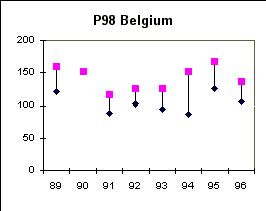
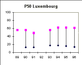
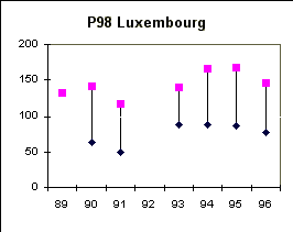
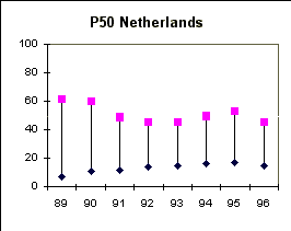

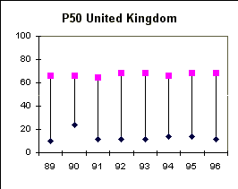
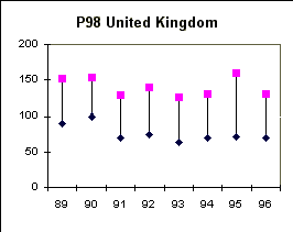
Figure 16. Range in reported 50-percentile values (in µg/m3, based on
hourly concentrations) and 98-percentile values (in µg/m3, based on hourly
concentrations) in Belgium, Luxembourg, the Netherlands and United Kingdom in the period
1989-1996.
4.6 Preliminary survey of exceedances in Italy
Information on ozone exceedances was received for 52 Italian stations
(for 1995: 68 stations). The coverage both for the land area and for the (urban)
population is expected to be insufficient (5 background stations, 22 urban stations). The
data were received at a very late stage and were in general inconsistent with the agreed
formats. Hence it has not been possible to include the Italian data in all sections of
this report. As far as possible the data have been included in the overview Tables 3-6. A
complication with the presented data is that only 13 of the 52 stations have a
data-coverage of 75% or more. Furthermore, a number of stations report only data over the
period July-December. This limits comparison of the Italian situation with the situation
in other Member States or in previous years.
The preliminary data indicate that the threshold values set for the
protection of human health and the threshold values set for the protection of vegetation
were exceeded frequently and substantially in Italy. The threshold value for information
of the population was exceeded during at least 86 days being the highest frequency in the
EU.
During the smog episode presented in Chapter 4.4 frequent violation of
the 180 µg/m3 threshold value was observed indicating that this episode is not
limited to NW-Europe but has a geographical extent to Southern Europe.
Acknowledgements
The authors are indebted to Herman Hootsen for the cartographic
contributions and for all further GIS support.
Note added in proof.
As a member of the EEA, Norway submitted information on ozone
exceedances to the Commission following the requirements and formats of the Ozone
Directive. The Norwegian data for the year 1996 was received by ETC-AQ on 29 September
1997; it was not possible to include these data in the analysis presented here. However, a
survey of the data showed that the Norwegian situation with respect to air pollution by
ozone is similar to the situation in the other Scandinavian countries. The data may be
summarized as:
- Norway submitted data for 15 monitoring stations (14 rural, one urban
station);
- observed maximum 1h concentration is 172 µg/m3; maximum
observed 8h average concentration is 157 µg/m3;
- exceedances of the threshold value of 180 µg/m3 has not been
observed;
- the threshold value of 110 µg/m3 for 8h average
concentrations (time period 12.00 -20.00) has been exceeded 130 times (on average 8.7
times per station);
- the threshold value of 65 µg/m3 for daily values has been
exceeded 1883 times (on average 126 times per station).


Document Actions
Share with others