2. THE METADATABASE
2.1. Metadatabase structure
The metadatabase was constructed using Microsoft Access software. This was selected
because it is potentially compatible with the databases on which the metadatabase is based
and can be run on most standard business machines.
The metadatabase is structured to minimise duplication of data. Figure 2.1 shows the
major component data tables in the database.
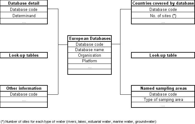
Figure .1 Schematic representation of the major elements of the metadatabase structure
The information is held in five tables:
European databases: This table holds the main information for each
database, including:
- the name of the database;
- the organisation/s responsible for data collection
and data management;
- the platform in which data are collected (reports
and/or computer system);
- availability of data; and
- other specific comments such as different phases of
the programme or actual status, it also contains the information of the type of sampling
site.
Countries covered by database: This table holds the history of
monitoring for each database by country. This allows the following lists to be produced:
- countries (inside and outside of the EEA area) where
monitoring has been carried out;
- the number of sites where sampling has been
undertaken in each country according to five different types of water bodies (rivers,
lakes, marine water, estuaries, groundwater);
- and the number of years of sampling per country.
-
Named sampling areas: This table contains:
- the name of the areas, regions or water bodies where
sampling has been undertaken; and
- the country where each area is situated.
Database detail: This table contains the
information of the determinands measured in each database. Each determinand is expressed
as:
- its name;
- the statistic held in the database;
- the number of years sampling has been carried out and
the year it began; and
- the unit in which the determinand is held, together
with comments related to the information given for specific sites.
Other information: This table holds data related to freshwater quality and quantity,
for example, climatic information (precipitation, atmospheric temperature, etc.), land
uses, and soil types.
The terms held in the metadatabase tables exactly match those reported in each database
to avoid inconsistencies. The data in the tables draw their data from many different and
disparate data sources and as a result different definitions are used (e.g. for parameters
measured, areas covered etc.). To solve this problem a number of look-up tables have been
created in order to standardise, as far as possible, the information held. These are
described in Sections 3 to 6.
2.2. Scope of Metadatabase
Information covering around
20 databases has been identified and collected. These fall into a number of broad
categories:
- those produced from monitoring schemes derived to
support EC legislatio;
- those related to international conventions based in
Europe; and
- those related to international conventions based
outside Europe
The picture is further complicated by the fact that some organisations implement
several monitoring programmes and produce a number of databases under the same umbrella.
This is true of organisations like the Oslo and Paris Commission which produce databases
related to specific topics such as pollution by mercury and from the titanium dioxide
industry.
Table A.1 and A.2 in Appendix A lists names and addresses of organisations that were
consulted for information on each monitoring programme and associate database. Details of
those who may be contacted for further information on a specific programme are also
included.
2.2.1. Databases Derived from EU Legislation and International Conventions.
Following the adoption of the Exchange of
Information Decision (77/795/EEC as amended by Decision 86/574/EEC), the state of 77
rivers in the EU has been monitored annually. The European Commission has prepared a
summary report based on information submitted by each Member State every three years since
1987. The European Commission also maintains databases relating to the quality of
designated waters under the Bathing Waters Directive (76/160/EEC), Freshwater Fish
Directive (78/659/EEC) and the Shellfish Waters Directive (79/923/EEC).
Some of the monitoring programmes included in
the metadatabase come from one international agreement or convention, but have been
divided into different records in the metadatabase according to their different type of
data (e.g. the record on PARCOM activities is different from that on the Joint Monitoring
Programme (JMP) and the different international programmes from the UN/ECE Convention on
the Long Range Transboundary Air Pollution each have different records).
Monitoring of European coastal and marine waters and the assessment of land-based
sources are undertaken by organisations such as the Helsinki Commission (which monitors
the Baltic Sea area), the Paris Commission (which monitors the Northeast Atlantic Ocean),
the North Sea Task Force (which monitors the North Sea) and the Mediterranean Action Plan
Co-ordination Unit (which monitors the Mediterranean Sea).
The International Council for the Exploration of the Sea (ICES) Environmental Data Bank
was established to support ICES own scientific needs as well as in support of the
monitoring programmes of the Oslo and Paris Commissions (OSPAR) and the Arctic Monitoring
and Assessment Programme (AMAP). ICES has also provided advice on data handling and data
assessment to the Helsinki Commission as well. All 19 ICES member countries have
contributed to the data bank that in October 1996 covered data from 1977 to 1995.
The effects of air pollutants on the quality of surface water and groundwater are
assessed under the International Co-operative Programmes (ICP) guidelines. Five ICP
programmes started in the 1980s within the UN/ECE Convention on Long-Range
Transboundary Air Pollution (LRTAP). The ICP on Assessment and Monitoring on Rivers and
Lakes (LRTAP/ICP-Waters) relating to water quality in Europe is included in the
metadatabase an "effect programmes", and holds data from 103 riverine sites and
63 lentic sites. In 1988 a UN/ECE International Pilot Programme on Integrated Monitoring
began which ran for 4 years and was replaced by the ICP Programme on Integrated Monitoring
(ICP-IM) of Air Pollution Effects on Ecosystems. This type of integrated monitoring, which
aims to predict the state of the ecosystems and their long-term changes, was found to be
successful following several years of assessment in surface and groundwaters. Data have
been held at the Environment Data Centre in Helsinki since 1988. The metadatabase contains
information on the five ICP-IM subprograms related to the quality of surface water and
groundwater. The determinands required for the phase 1993-96 are also included in the
metadatabase as an effect programme.
2.2.2. Databases derived from monitoring programmes based in Europe
The CORINE Information System was developed within the framework of the CORINE
(Co-ordination of Information on the Environment) Programme 1985-1990, in order to provide
information on the state of the environment in Europe. Since 1990, it has since been
maintained by the EEA. In addition to the information from the CORINE Programme the
database also contains data resulting from the implementation of the Bathing Waters
Directive and the Exchange of Information Decisions. The data are held in an ORACLE
database, which is associated with ARC/INFO GIS software which runs the CORINE Information
System.
The quality of selected rivers and lakes in
the EU area is also surveyed by the Statistical Office of the European Communities
(EUROSTAT). Information gathered from a questionnaire sent to each EU country is held in a
database built using various platforms including Microsoft Access which has been updated
annually since 1970.
The EEA Task Force undertook a data compilation in order to identify and compare the
environmental problems for the first State of Environment Report for Europe (the Dobris
Assessment). Information on the quality of rivers and lakes was collected from a
questionnaire forwarded to national focal points of European countries not only in the EEA
area, but also in the east of Europe. As a result, data on water quality indicators were
obtained from a total of about 700 monitoring stations in twenty-eight countries.
The Organisation for Economic Co-operation and Development (OECD) publishes the OECD
Environmental Data Compendium every two years containing the response to a questionnaire,
sent jointly with that from EUROSTAT since 1988, from twenty-two countries. The
metadatabase holds only those data related to European rivers and lakes.
The type of water sampled (freshwater, coastal water and groundwater) and the
geographical coverage are the main features differentiate between the twenty-seven
monitoring programmes collated in the metadatabase. Some of the organisations (e.g. the
European Environment Agency Task Force or the European Commission) have collected data
covering a wide range of European rivers and lakes, in the EEA and EU areas. Other
organisations (such as the International Commission for the Protection of the river Rhine,
the International Commission for the Protection of the river Elbe) maintain programmes
concerned with the protection of a specific river or basin, e.g. monitoring of the Rhine,
the Elbe or the Danube, as shown in Table 2.1.
2.2.3. Databases derived from monitoring programmes based outside Europe
Two of the programmes
collected in the metadatabase have a world-wide coverage. These are the Global Environment
Monitoring System (GEMS) maintained by the World Health Organisation and the Global Runoff
Data Centre (GRDC) database operated under the auspices of the World Meteorological
Organisation. Data from European countries, in both cases, are grouped in a
"European" region. The GEMS/WATER programme is a joint UNEP/WHO/UNESCO/WMO
programme on global water quality monitoring. The information on the quality of fresh and
ground water is held in a database maintained in the Canada Centre for Inland Waters. The
GRDC, established at the Federal Institute of Hydrology in Koblenz, Germany, maintains and
updates information on water quantity of rivers.
Table .1 Summary of the databases or monitoring programmes collected in the
metadatabase
Database name
|
Comments
|
| AMAP/Freshwater |
At the Ministerial Conference in Rovaniemi, Finland, in June 1991, the
Ministers from the eight Arctic countries agreed to develop an Arctic Monitoring and
Assessment Programme (AMAP). The primary objectives of the programme are the measurement
of the levels of anthropogenic pollutants and assessment of their effects in relevant
component parts of the Arctic environment. The assessment will include monitoring for
fresh and marine waters and will be presented in status reports. As an initial priority.
the AMAP will focus on persistent organic contaminants, selected heavy metals and elements
and radionuclides. Ultimately, AMAP should include ecological indicators to provide a
basis for the assessment of the status of the Arctic ecosystems. |
| AMAP/Marine |
At the Ministerial Conference in Rovaniemi, Finland, in June 1991, the
Ministers from the eight Arctic countries agreed to develop an Arctic Monitoring and
Assessment Programme (AMAP). The primary objectives of the programme are the measurement
of the levels of anthropogenic pollutants and assessment of their effects in relevant
component parts of the Arctic environment. The assessment will include monitoring for
fresh and marine waters and will be presented in status reports. As an initial priority.
the AMAP will focus on persistent organic contaminants, selected heavy metals and elements
and radionuclides. Ultimately, AMAP should include ecological indicators to provide a
basis for the assessment of the status of the Arctic ecosystems. The "Named water bodies" considered are the
European coastal areas. The areas in Canada or in United States has not been considered in
this metadatabase. |
Table 2.1 continued
Database name
|
Comments
|
| AMHY |
The development of the Data Base containing data from south European
countries (AMHY area) is undertaken by the European AMHY (Alpine and Mediterranean
Hydrology) group (Topic I), within the FRIEND (Flow Regimes from International
Experimental and Network Data) research programme, as a contribution to Unesco's Fourth
International Hydrological Programme. The
number of years registered is the mean record length by country, that means a total
average of 25 year sampling. Although the start of analysis is registered from 1910, it
does not mean a total length of 25 years per time series. There are some series beginning
before 1910 and ending after 1990, while there are others which record length is shorter.
Data are available, in general terms, for the last 25 years up to 1990 in almost every
AMHY countries. |
| Baltic Monitoring Programme |
The Helsinki Commission's monitoring and assessment activities are mainly
carried out under the Baltic Monitoring Programme (BMP), based on the Convention on the
Protection of the Marine Environment of the Baltic Sea area (Helsinki Convention,
1974/1992). Monitoring has been carried out at about 600 stations in the Baltic Sea since
1979. Heavy metals and synthetic organics are assessed in biota, as well as other
biological indicators, and analysis of nutrients, physicochemical and organic pollution
are undertaken in water. |
| Bucharest/85 |
In 1985 The Bucharest Danube Declaration was signed by the riparian
countries with the objective of accomplishing the water quality monitoring network of the
Danube river, along its border section to Germany, Austria and Slovakia. |
| CORINE/WATER |
The CORINE (COordination of INformation on the Environment) Programme was
adopted in 1985 by the European Community's Council of Ministers, with the objective of
gathering, co-ordinating and improving the consistency of information on the state of the
environment in the European Community. The
CORINE Information System on water features contains data about 12 surface water
parameters from 1066 gauging stations in meridional EC countries, during the years between
1970-85. It also contains climatological data from 4773 stations in all EC wide coverage.
49141 segments have been digitised in order to get a distribution of major surface water
bodies in EC countries. The System Information contains a digital elevation model . |
| EC Bathing Waters Directive |
The Bathing Waters Directive 76/160/EEC sets standards for bathing water
(fresh or sea water) quality during the bathing season in terms of physical, chemical and
microbiological determinands. Monitoring requirements are defined in terms of minimum
frequency, location and reference methods of analysis. The number of sampling sites has increased with time. About 15000 sites
were tested for the 1991 campaign while a total of about 17000 were tested in 1994. The
total number of sampling sites have been updated to 1994 campaign.
Data from the different member states are collected
in DOS format although a conversion to Access v2.0 is currently being carried out. |
| EC Freshwater Fish Directive |
The Freshwater Fish Directive 78/659/EEC sets quality objectives for
designated fresh waters in order to support fish life. Two types of water are to be
designated, those suitable for salmonids and those suitable for cyprinids. Objectives are
based on physical and chemical determinands. Minimum monitoring frequencies and some
reference methods for analysis are given. |
| EC Shellfish Waters Directive |
The Shellfish Waters Directive 79/923/EEC sets objectives for designated
coastal and brackish waters in order to support shellfish. These are based on physical,
chemical and microbiological determinands. Minimum monitoring frequencies are given. A
separate Directive (91/492/EEC) is concerned with protecting consumers of shellfish. |
| Elbe/89 |
ICPE: International Commission for the Protection of the River Elbe. Data
updated to 1993 according to the Commission Report. |
Table 2.1 continued
Database name
|
Comments
|
| Exchange of Information Directive |
Council Decisions 77/795/EEC and 86/574/EEC established a common procedure
for the exchange of information on the quality of surface freshwater. It requires
monitoring for specified water quality determinands at specific measuring stations
(covering the main rivers in each Member State). Results of monitoring must be submitted
to the Commission. Reference methods of analysis are given. |
| FRIEND |
The development of the European Water Archive (EWA) is undertaken within
the FRIEND (Flow Regimes from International Experimental and Network Data) research
programme, as a contribution to Unesco's Fourth International Hydrological Programme. The
first phase of the project finished in 1989, and it was followed by the four-year study
phase, concluding in 1993. The EWA comprises
data from the FRIEND and Alpine and Mediterranean Hydrology (AMHY) programmes. This means
that some countries contribute to the EWA with data from both programmes. Nevertheless, a
complete data set just for the AMHY programme is collected in this database.
The number of years registered is the mean record
length by country, that means a total average of 27 year sampling.
The FRIEND project began in 1985. No assessment of
the monitoring has been carried out.
Agencies of different countries have provided data
to the FRIEND project free of charge as the condition it is used solely for FRIEND
research. Data are available, in general terms, for the last 27 years up to 1993 for
almost every FRIEND area country. |
| GEMS/WATER |
GEMS/Water was initiated in 1976 as a freshwater monitoring network. It is
operated by UNEP and WHO with the support of UNESCO and WMO as part of the GEMS
environmental pollution monitoring programmes. In August 1990 a new phase for GEMS/Water
was approved, where long-term objectives were defined. |
| GRDC/WMO |
The GRDC database operates under the auspices of the WMO under the
guidance of an international Steering Committee. It contains information of the discharges
measured in 600 sites all over Europe (WMO Region 6). |
| HELCOM/PLCs |
The objective of the Pollution Load Compilations (PLCs) is to measure the
direct inputs to the Baltic Sea from the land-based uses, according to the Convention on
the Protection of the Marine Environment of the Baltic Sea Area, 1974 (Helsinki
Convention). The PLC tasks have been carried out in stages: PLC-1 was a first compilation
of different sets of data. The results were published in BSEP No 20. PLC-2 was a pilot
programme based on the results from PLC-1. It tried to undertake a basic coverage of major
direct sources of pollution. PLC-3 is the current stage of the programme, which Guidelines
were prepared in 1993 aiming a better assessment of direct discharges to the Baltic Sea. |
| HYDABA/ICPR |
In 1950 the International Commission for the Protection of the Rhine
against Pollution (IPCR) was founded in Basle. In 1963, the International Convention (Bern
Convention) detailed the tasks of the IPCR including to monitor the state of the Rhine and
to prepare international conventions on chemical pollution (Rhine Convention 1976),
chlorides (Bonn Convention 1976 and 1991) and thermal pollution (ICPR's work in this field
is now ended). In 1987, the Rhine countries as well as the ICPR elaborated a comprehensive
action programme, the Rhine Action Programme (RAP) which defined targets to be achieved by
the year 2000. The ICPR has a monitoring programme which is revised regularly, the latest
was published in July 1994 for 1995. Data are
held in the HYDABA database of the Federal Hydrological Institute in Koblenz. |
Table 2.1 continued
Database name
|
Comments
|
| ICES Environmental Data Bank |
The International Council for the Exploration of the Sea
(ICES) Environmental Data Bank was established to support ICES own scientific needs
as well as in support of the monitoring programmes of the Oslo and Paris Commissions
(OSPAR-12 countries) and the Arctic Monitoring and Assessment Programme (AMAP). ICES has
also provided advice on data handling and data assessment to the Helsinki Commission. All
19 ICES member countries have contributed to the data bank that in October 1996 covered
data from 1977 to 1995. The following data types are included:
contaminants in finfish and
shellfish (300,000 records);
contaminants in sea water (ca.
280,000 records);
contaminants in sediments (ca.
73,000 records);
data from measurements of the
biological effects of contaminants (EROD and OEB (ca. 3,000 records);
fish disease prevalence (ca.
15,000 records);
quality assurance information
The database is held at ICES in Copenhagen Denmark. |
| IIASA/Elbe-Oder |
The International Institute for Applied System Analysis developed a
database for the Upper Elbe/Oder River Basin based on an atmospheric deposition model,
water pollution and a soil sampling programme for heavy metal pollution. |
| IIASA/Rhine |
The International Institute for Applied System Analysis developed a
database for the Rhine River Basin based on aqueous and atmospheric emissions and
deposition for 1955-1990. |
| JAMP/OSPAR94 |
The monitoring activities of the new OSPAR Convention 1994 will be carried
out by the Environmental Assessment and Monitoring Committee (ASMO) under the Joint
Assessment and Monitoring Programme (JAMP). OSPAR 1994 aims to prepare a Status Quality
Report 2000 with the data from the JMP and the MMP (NSTF) collected by the year 2000. The data held in this metadatabase come from the agreements
achieved in the Joint Meeting of the Oslo and Paris Commissions in Brussels, June 1995. |
| Joint Monitoring Programme |
The Paris Convention represents the second step taken by the maritime
states bordering the North East Atlantic in combating pollution of the marine environment
of that region. It followed on from the Oslo Convention which deals with the control of
pollution of the seas by the dumping of harmful substances. It introduced two lists of
substances for control, the Black and Grey lists. Contracting countries are obliged to
eliminate pollution by substances on the Black List and limit pollution by substances on
the Grey List. This approach was later adopted in EC legislation. The Convention is
administered by a Commission (PARCOM) which required, amongst other things, marine
environmental monitoring to be undertaken. A Joint Monitoring Programme (JMP) has been
established with the Oslo Commission. |
| LRTAP/ICP-IM |
The Integrated Monitoring Programme (ICP IM) is part of the Effects
Monitoring Strategy under the UN/ECE Long-Range Transboundary Air Pollution Convention. The Integrated Monitoring (IM) projects are implemented under
the auspices of the Working Group of Environmental Monitoring Data, which is supported by
the Environment Committee of the Nordic Council of Ministers.
Five sub-programmes related to quality of freshwater
and groundwater are being carried out:
* GW: groundwater chemistry;
* RW: runoff water chemistry;
* LC: lake water chemistry;
* RB: hydrobiology of streams;
* LB: hydrobiology of lakes. |
Table 2.1 continued
Database name
|
Comments
|
| LRTAP/ICP-Water |
The sulphur protocol to the Convention on Long-Range
Transboundary Air Pollution of the UNECE was adopted in 1985 in Helsinki under the
auspices of the ECE Protection of the Environment framework. This network has been
established to evaluate long range transport and deposition of acidifying compounds. |
| MEDPOL |
Mediterranean Action Plan (MAP) (Phase I 1975 - 1980) led to
the long term Mediterranean Pollution Monitoring and Research Programme (MEDPOL). Phase II
(1981- ) included monitoring at four levels: sources of pollution; near shore areas;
offshore areas; and atmospheric transport of pollutants. Monitoring in MEDPOL is carried out for nine different matrices (air,
biota -except plankton-, effluent, plankton, precipitation, seashore, sediment, suspended
matter, sea water). In this database only the determinands assessed in biota, plankton,
sediment, suspended matter and sea water are recorded. |
| Monitoring Master Plan |
The North Sea Task Force was established following a
Ministerial Declaration made at the second International Conference on the Protection of
the North Sea held in London in November 1987. Its aim was to enhance scientific knowledge
and understanding of the North Sea environment, to provide more consistent and dependable
data and to permit links between contaminant inputs, concentrations and effects to be
established with greater confidence. A North Sea Task Force Monitoring Master Plan (MMP)
has been developed which builds on the monitoring carried out under the Joint Monitoring
Programmes (JMP) of the Oslo and Paris Commissions. |
| PARCOM/ Mercury |
Paris Commission tries to reduce the Hg emissions from waste
chlor-alkali plants. This record shows the state of emissions over the countries agreeing
the Paris Convention updated to 31 December 1992.. There is no chlor-alkali industry in the catchment area for Denmark,
Iceland and Ireland. |
| PARCOM/ Radioactive |
In 1986, the Paris Commission agreed to collect information
from Contracting Parties about discharges of radioactive substances from nuclear
installations in the Convention Area from 1985 onwards. Information is provided from: * nuclear power stations;
* nuclear fuel reprocessing plants;
* nuclear fuel fabrication plants and
* research and development facilities. |
| PARCOM/ Refineries |
The Paris Commission adopted Guidelines for discharges from new refineries
in 1980. The number of refineries has decreased between 1980 and 1990. |
| PARCOM/ Titanium Dioxide |
The discharges from the titanium dioxide industry are
regularly assessed over the countries agreeing the Paris Convention. There is no
production of TiO2 in Denmark, Ireland, Iceland, Portugal and Sweden. Germany and Belgium
have insignificant emissions, and strong acids were dumped up to 31 December 1989. Dumping
continues in Spain. |
| Regensburg/87 |
In 1987 the Regensburg Agreement was signed between Austria, Germany and
the EU with the objective of accomplishing the water quality monitoring network of
transboundary rivers. |
| SIREN-IW/OECD |
In the Recommendations adopted on 31st January 1991 by the
OECD Council, and approved by Environment Ministers, Member governments agreed to ensure
the development of objective, reliable and comparable environmental statistics and
information at international level. SIREN
(System of Information on Resources and the Environment) is the compilation and
publication of environmental data. These data are yearly published in the OECD
Environmental Data Compendium. The state of the environment is assessed for: inland
waters, air, land, forest, wild life, waste, risks for human health and noise. |
| The Dobris Assessment |
Information in this Report is based on questionnaires forwarded to
national focal points; various national and regional state of the environment reports; and
a review of the scientific literature concerning the environmental state of European
rivers, lakes and reservoirs. |


Document Actions
Share with others