Appendix 1 Characterisation of the
ozone phenomenology
This appendix consists of the tables and figures mentioned in
section 5.5 and subsequent sections.
I.1 Ozone exceedances and the
weather type over Middle Europe
Table I.1: Definition of the GWL
weather types(1) observed over the April-August 1994,1995 and 1996 periods.
| Weather
type(2) |
Definition |
| BM |
ridge of high pressure over Middle Europe |
| HB |
high over the British Isles; high pressure
over Middle Europe |
| HM |
closed high over Middle Europe |
| HNa |
high over the North Sea; high pressure
over Middle Europe |
| HNFa |
high over the North Sea - Scandinavia;
high pressure over Middle Europe |
| NEa |
high pressure over Middle Europe with
predominantly north-easterly flows |
| NWa |
high pressure over Middle Europe with
predominantly north-westerly flows |
| Nz |
low pressure over Middle Europe with
predominantly northerly flows |
| Sa |
high pressure over Middle Europe with
predominantly southerly flows |
| SEa |
high pressure over Middle Europe with
predominantly south-easterly flows |
| SWa |
high pressure over Middle Europe with
predominantly south-westerly flows |
| TrW |
trough of low pressure over West Europe |
| TrM |
trough of low pressure over Middle Europe |
| Wa |
high pressure over Middle Europe with
predominantly westerly flows |
| Wz |
low pressure over Middle Europe with
predominantly westerly flows |
(1) classes that contribute less
than 7% to the exceedances for each Member State are not considered
(2) bold and normal characters refer to anticyclonic
and cyclonic weather types, respectively.
Table I.2: Total ozone exceedances(1)
(N) and percentage per GWL weather type(2) reported
over the April-August 1994,1995 and 1996 periods (456 days).
| Weather type
|
days |
SE |
FI |
DK |
DE |
LU |
NL |
BE |
AT |
IT |
FR |
GB |
IE |
GR |
ES |
PT |
E.U. |
| BM |
16
|
57
|
100
|
55
|
44
|
42
|
36
|
31
|
29
|
23
|
35
|
23
|
- |
9 |
34
|
5 |
36
|
| Sa |
2 |
- |
- |
9 |
14
|
9 |
12
|
2 |
14
|
9 |
4 |
2 |
- |
0.2 |
1 |
- |
10
|
| HM |
7 |
7 |
- |
36
|
9 |
14
|
27
|
28
|
3 |
4 |
11
|
30
|
15
|
3 |
7 |
- |
10
|
| SEa |
2 |
- |
- |
- |
7 |
9 |
9 |
11
|
12
|
8 |
7 |
8 |
8 |
1 |
2 |
- |
7 |
| NEa |
4 |
- |
- |
- |
5 |
11
|
5 |
6 |
1 |
4 |
11
|
26
|
31
|
9 |
1 |
48
|
6 |
| Wa |
5 |
- |
- |
- |
4 |
4 |
5 |
7 |
3 |
11
|
8 |
- |
- |
8 |
9 |
14
|
5 |
| HNFa |
2 |
- |
- |
- |
5 |
4 |
4 |
10 |
4 |
3 |
2 |
1 |
- |
3 |
- |
- |
4 |
| Wz |
8 |
- |
- |
- |
2 |
1 |
- |
- |
3 |
8 |
4 |
0.5 |
- |
15
|
10
|
5 |
4 |
| SWa |
2 |
36
|
- |
- |
3 |
- |
- |
- |
11 |
1 |
0.4 |
- |
- |
- |
4 |
- |
3 |
| HB |
7 |
- |
- |
- |
0.3 |
- |
1 |
1 |
1 |
4 |
6 |
3 |
8 |
8 |
16
|
14
|
2 |
| NWa |
1 |
- |
- |
- |
3 |
3 |
0.1 |
3 |
1 |
2 |
3 |
5 |
8 |
1 |
- |
- |
2 |
| HNa |
4 |
- |
- |
- |
1 |
- |
- |
- |
12
|
5 |
2 |
- |
- |
2 |
2 |
- |
2 |
| TrW |
6 |
- |
- |
- |
1 |
- |
- |
- |
3 |
2 |
0.4 |
- |
15
|
4 |
- |
5 |
1 |
| TrM |
11
|
- |
- |
- |
- |
- |
- |
- |
0.2 |
2 |
0.2 |
- |
8 |
14
|
0.4 |
5 |
1 |
| Nz |
3 |
- |
- |
- |
0.2 |
1 |
- |
0.4 |
1 |
1 |
1 |
- |
8 |
5 |
0.4 |
- |
1 |
| N |
|
14 |
2 |
11 |
4891 |
101 |
685 |
258 |
583 |
1067 |
1151 |
208 |
13 |
422 |
265 |
21 |
9687 |
(1) August 1996 is not included
for France
(2) classes that contribute less than 7% to the
exceedances for each Member State are not considered. Bold and normal characters refer to
anticyclonic and cyclonic weather types, respectively.
The second column refers to the occurrence of the
weather types (in % days). The three highest values in bold and the maximum is underlined.
Dash symbol means that no exceedance was recorded.
Table I.3: Total ozone exceedances(1)
(N) and average number per day of GWL weather type(2)
reported over the April-August 1994, 1995 and 1996 period (456 days).
| GWL type |
days |
SE |
FI |
DK |
DE |
LU |
NL |
BE |
AT |
IT |
FR |
GB |
IE |
GR |
ES |
PT |
E.U. |
| Sa |
2 |
- |
- |
0.14
|
96.1
|
1.3
|
11.9
|
0.9 |
11.6
|
13.9
|
7.1 |
0.6 |
- |
0.1 |
0.4 |
- |
144
|
| SEa |
2 |
- |
- |
- |
42.5
|
1.1
|
8.0
|
3.6
|
8.6
|
11.1
|
9.6
|
2.0 |
0.13
|
0.8 |
0.8 |
- |
88
|
| NWa |
1 |
- |
- |
- |
33.5
|
0.8
|
0.3 |
2.0 |
2.0 |
4.3
|
9.8
|
2.8
|
0.25
|
1.0 |
- |
- |
57
|
| BM |
16
|
0.11
|
0.03
|
0.08
|
29.6 |
0.6 |
3.4 |
1.1 |
2.4 |
3.5 |
5.9 |
0.7 |
- |
0.5 |
1.2
|
0.01 |
49 |
| HM |
7 |
0.03
|
- |
0.13
|
14.9 |
0.5 |
6.2
|
2.4
|
0.5 |
1.3 |
4.7 |
2.1
|
0.07 |
0.4 |
0.6 |
- |
33 |
| NEa |
4 |
- |
- |
- |
16.1 |
0.7 |
1.9 |
0.9 |
0.3 |
2.8 |
7.8
|
3.4
|
0.25
|
2.3
|
0.2 |
0.63
|
37 |
| HNFa |
2 |
- |
- |
- |
20.9 |
0.4 |
2.6 |
2.3
|
2.1 |
3.0 |
2.6 |
0.3 |
- |
1.3 |
- |
- |
35 |
| SWa |
2 |
0.50
|
- |
- |
16.7 |
- |
- |
- |
6.6
|
1.5 |
0.5 |
- |
- |
- |
1.1
|
- |
27 |
| Wa |
5 |
- |
- |
- |
7.7 |
0.2 |
1.3 |
0.7 |
0.7 |
4.9 |
3.7 |
- |
- |
1.3 |
1.0 |
0.13
|
21 |
| HNa |
4 |
- |
- |
- |
4.1 |
- |
- |
- |
4.0 |
2.9 |
1.4 |
- |
- |
0.4 |
0.2 |
- |
13 |
| Wz |
8 |
- |
- |
- |
3.2 |
0.03 |
- |
- |
0.4 |
2.3 |
1.2 |
0.03 |
- |
1.7
|
0.7 |
0.03 |
10 |
| HB |
7 |
- |
- |
- |
0.6 |
- |
0.2 |
0.1 |
0.20 |
1.4 |
2.3 |
0.2 |
0.03 |
1.1 |
1.4
|
0.10
|
8 |
| TrW |
6 |
- |
- |
- |
1.6 |
- |
- |
- |
0.6 |
0.6 |
0.2 |
- |
0.07 |
0.6 |
- |
0.04 |
4 |
| Nz |
3 |
- |
- |
- |
0.7 |
0.1 |
- |
0.1 |
0.3 |
0.7 |
0.6 |
- |
0.08 |
1.5
|
0.1 |
|
4 |
| TrM |
11
|
- |
- |
- |
- |
- |
- |
- |
0.02 |
0.4 |
0.0 |
- |
0.02 |
1.2 |
0.02 |
0.02 |
2 |
| N |
456 |
14 |
2 |
11 |
4891 |
101 |
685 |
258 |
583 |
1067 |
1151 |
208 |
13 |
422 |
265 |
21 |
9687 |
(1) August 1996 is not included
for France
(2) classes that contribute less than 7% to the
exceedances for each Member State are not considered. Bold and normal characters refer to
anticyclonic and cyclonic weather types, respectively.
The second column refers to the occurrence of the
weather types (in % days). The three highest values in bold and the maximum is underlined.
Dash symbol means that no exceedance was recorded.
I.2. Ozone conducive meteorological
parameters
The eight following characteristic wide-spread ozone episodes were
selected during the 1994, 1995 and 1996 growing seasons, in order to characterise the
meteorological situations which are conductive of high ozone levels: (1) 23 to
30 June 1994; (2) 19 July to 2 August 1994; (3) 3 to 9 May 1995; (4) 27 June to
3 July 1995; (5) 23 to 28 July 1995; (6) 18 to 24 April 1996; (7) 3 to 9 June 1996; (8) 10
to 14 June 1996. A total of 4347 ozone exceedances of the population information threshold
were reported during the 62 corresponding days (i.e. 45 % of the total exceedances
recorded over the April-August 1994, 1995 and 1996 periods).
Table I.4: The selected episodes: duration (days),
exceedances of the population information threshold (Nexc. ), Member States
where they were recorded, and daily GWL weather types (days)
Episode |
Duration
in days |
Nexc. |
Member States |
GWL type (days) |
1 |
8 |
379 |
AT BE DE ES FR GB IT LU NL |
Wa (1) BM (7) |
2 |
15 |
1828 |
AT BE DE DK ES FI FR GB GR IT LU NL SE |
NEz (3) BM (8) Sa (4) |
3 |
7 |
605 |
AT BE DE DK ES IE FR GB IT LU NL SE |
HM (5) Nz (2) |
4 |
7 |
279 |
AT BE DE ES FR GB GR IE IT LU NL |
HB (2) NWa (4) NWz (1) (1) |
5 |
6 |
286 |
AT BE DE ES FR GB IE IT LU NL PT |
Wa (2) SEa (4) |
6 |
7 |
253 |
AT DE ES FR IT SE |
HM (1) SWa (5) BM (1) |
7 |
7 |
534 |
AT BE DE DK ES FR GB GR IT LU NL SE |
TrW (1) BM (6) |
8 |
5 |
183 |
AT DE ES FI FR IT |
BM (3) HB (2) |
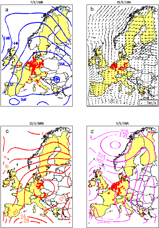
Figure I.1: Examples of the daily Europe scale
thematic maps performed for the 62 days of the eight selected 1994, 1995 and 1996 episodes
for (a) the topology of the 850 pressure surface at 12 UTC (dm), (b) the horizontal wind
at 12 UTC for the 850 mb (not shown) and 1000 mb levels, (c) the daily maximum surface
temperature (°C) and (d) the 12-18 UTC average surface solar radiation (W.m-2.s).
Stations which reported ozone exceedance(s) of 180 mg/m3 threshold are shown
in red points.
Data sources are (a) the European Meteorological Bulletin of the
Deutscher Wetterdienst (Offenbach, Germany), (b, d) the 0.5° resolution analyses from the
European Centre of Meteorological Weather Forecast (Reading, United-Kingdom) and (c) the
MARS-JRC meteorological station-database (Ispra, Italy).
I.3 Photochemical formation of
ozone
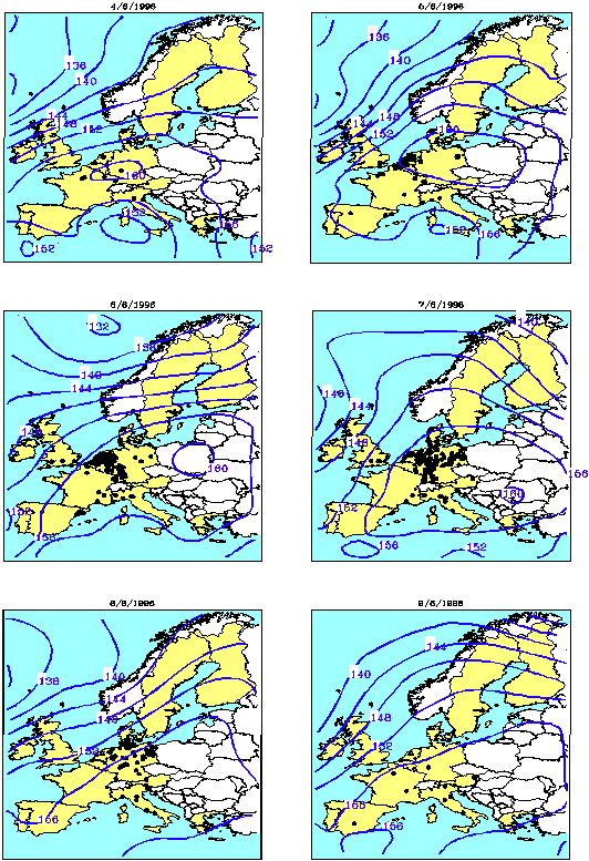
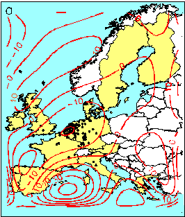
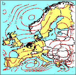
Figure I.2 Stations which reported exceedance(s) of 180
mg/m3 ozone concentration (black points) and topology of the 850 mb pressure
surface at 12 UTC (dm) derived from the European Meteorological Bulletin of the
Deutscher Wetterdienst (Offenbach, Germany) over the 4-9 June 1996 period (selected
episode n°7), which was characterised by a ridge of high pressure over Middle Europe (BM
GWL weather type).
Table I.5: Annual and seasonal average (1) daily
mean and maximum O3 and Ox (O3 + NO2 ) concentrations
(mg.m-3) for selected urban and rural stations in the EU, over the
1994-1995 period (2).
Stations |
|
Average daily maximum concentrations |
| |
|
Annual |
April - September |
October
- March |
| Station (Member
State) |
Altitude |
Type |
|
O3 concentrations |
| Athens (GR) |
50 m |
Urban |
|
104 (35 %) |
121 (24 %) |
77 (37%) |
| Barcelona (ES) |
75 m |
Urban |
|
58 (45%) |
74 (33%) |
44 (43%) |
| London (GB) |
20 m |
Urban |
|
51 (62%) |
70 (51%) |
39 (54%) |
| Berlin (DE) |
35 m |
Urban |
|
74 (55%) |
100 (37%) |
47 (47%) |
| Veciana (ES) |
726 m |
Rural |
|
90 (34%) |
112 (25%) |
71 (25%) |
| Agullana (ES) |
217 m |
Rural |
|
72 (27%) |
84 (19%) |
60 (21%) |
| Lady Bower Res. (GB) |
420 m |
Rural |
|
80 (36%) |
96 (33%) |
67 (27%) |
| Spessart (DE) |
485 m |
Rural |
|
83 (48%) |
107 (34%) |
56 (38%) |
| Station (Member
State) |
Altitude |
Type |
|
Ox concentrations |
| Athens (GR) |
50 m |
Urban |
|
155 (33%) |
164 (32%) |
138 (33%) |
| Barcelona (ES) |
75 m |
Urban |
|
140 (38%) |
157 (32%) |
126 (40%) |
| London (GB) |
20 m |
Urban |
|
132 (37%) |
142 (38%) |
126 (35%) |
| Berlin (DE) |
35 m |
Urban |
|
87 (43%) |
110 (34%) |
64 (28%) |
(1) Only complete available data (i.e. 24 hourly
values per day) are taken into account (2) O3 ( and
Ox) complete available data: Athens: 421 (343) days, Barcelona: 363 (265) days, London:
480 (461) days, Berlin: 721 (678) days, Veciana: 580 days, Agullana: 570 days, Lady Bower
Reservoir: 520 days, Spessart: 640 days.
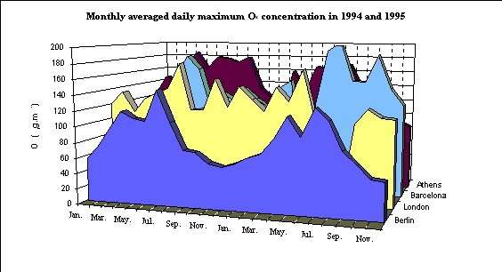
Figure I.3: Monthly average(1) daily maximum Ox
(O3 + NO2 ) concentrations (mg.m-3) in Athens, Barcelona,
London and Berlin, over the 1994-1995 period.
(1) No data for April 1995 in Barcelona and for July and
August 1995 in London.
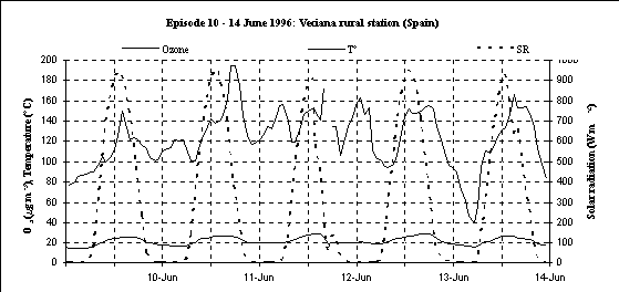
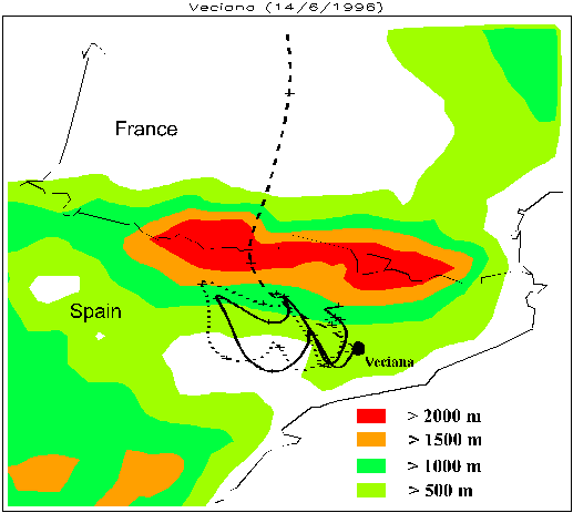
Figure I.4a: Hourly ozone (O3),
temperature (T°) and solar radiation (SR) measurements, at Veciana elevated (726m) rural
station (Spain), from the 10 to the 14 June 1996. An atypical daily evolution of
the concentrations is observed, with high concentrations also reported during the night.
Figure I.4b: 96h-backward trajectories initialised on
the 14 June 1996, at 10 UTC and at 1000 m (solid line), 1500 m (dotted line), 3000 m
(dashed line) altitude levels for Veciana reception site, respectively (Koffi, 1997). The
Pyrénées altitude range is given by the PERIDOT 10km -resolution model (Imbard et al.,
1986). Veciana is located in a sheltered zone south of the Pyrenees where stagnation and
vortex circulation of the air masses in the low troposphere induced a particular daily
evolution and an increase of the ozone concentration level.
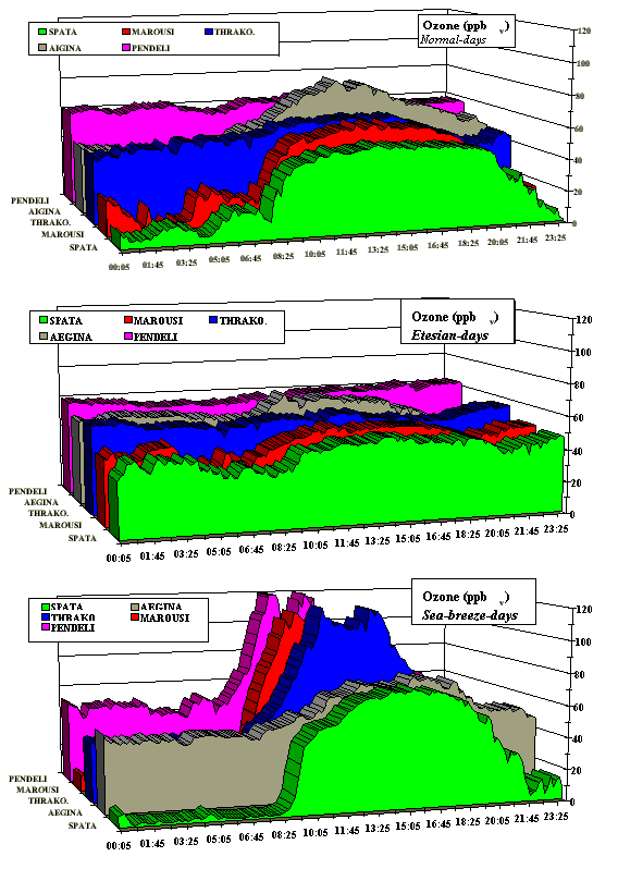
Figure I.5: Mean diurnal ozone variations at several
locations in the greater Athens area, as a function of the wind regime. These typical
diurnal variations were summarised from a time series of 24 days during August/September
1994 MEDCAPHOT campaign (Suppan et al., 1998).
I.4. Long-range transport
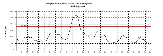
Figure I.6a: Hourly Ox (O3
+ NO2 ) measurements at Lullington Heath rural station during episode
n°5.
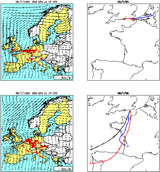
Figure I.6b: horizontal wind
field at 850 hPa (left) and backward trajectories at (a) 500, (b) 1500 and (c) 3000 m
altitude, for Lullington Heath (England) reception point (right), on the 25 and 26 July
1995 (Koffi, 1997). The air flows changed from maritime to continental direction from
the 24 to the 25 July 1995 and were again maritime on the 26. The air in the boundary
layer in South England came from the Benelux on the 25 July, where it had remained for
more than 12 hours in a highly polluted environment. The increase of ozone levels observed
in Lullington Heath is obviously due to long-range transport from the continent.
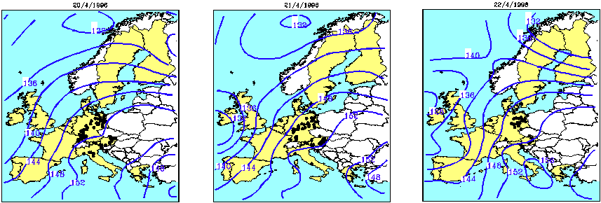
Figure I.7a: Exceedances of the population
information threshold and topology of the 850 mb surface at 12 UTC (dm), on the 20, 21 and
22 April 1996 (episode n° 6).
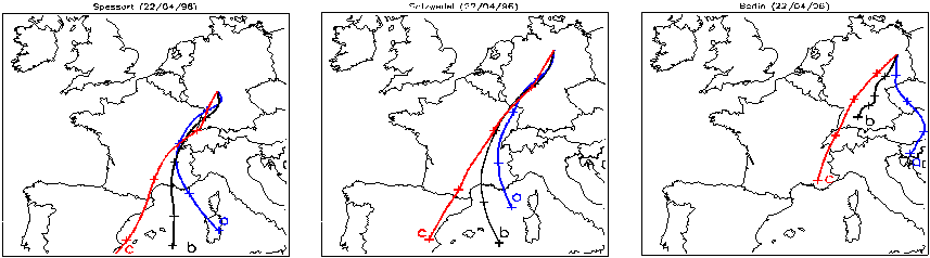
Figure I.7b: 48-h backward trajectories initialised
at 14 UTC on the 22/04/96 at (a) 500, (b) 1500 and (c) 3000 m altitude, for Spessart,
Salzwedel and Berlin reception sites, in Germany (Koffi, 1997). Episode of 18-24 April
1996 occurred during an anticyclonic situation over Middle Europe with predominantly
south-westerly flows. The centre of the anticyclone quickly moved from Germany to
East-Southeast on the three first days, but ozone exceedances where still recorded in that
country on the following days. Long-range transport from North-east of France and from
Austria is shown for three reception sites in Germany, over the 20-22 April 1996 period.
I.5 Transport down from the
upper troposphere/lower stratosphere
Figure I.8: Vertical velocity isolines (mm.s-1)
on the 5 May 1995, at 12 UTC for the (a) 1000 mb and (b) the 850 mb pressure levels,
derived from the 0.5° lat/long resolution analyses from the European Centre for Medium
range Weather Forecasts (ECMWF, UK)
The wind vertical velocity calculated over Europe for the 850 and
1000 mb pressure levels during episode n°3 shows a subsidence of the air masses during
the three first days, with its centre over Benelux on the 5 May 1995.
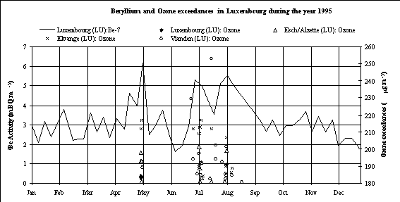
Figure I.9: Weekly average 7Be
surface concentrations at Luxembourg (from the REM data bank; De Cort, 1997) and 180 mg.m-3
ozone exceedances at Luxembourg, Esch/Alzette, Elvange and Vianden stations in Luxembourg
during 1995.
Beryllium 7 (a tracer of air coming from the free troposphere)
surface concentrations measured in Luxembourg in 1995, show a significant peak of the
concentrations during the May ozone episode (episode n°3) which indicates down transport
of ozone from the upper troposphere/lower stratosphere. Moreover, the 1995 two main ozone
summer episodes (episodes n° 4 and n° 5) coincide with peaks of 7Be
concentrations, which also suggest a contribution of ozone coming from the free
troposphere, in addition to local photochemical formation.


Document Actions
Share with others