next
previous
items

Figure

European average air temperature anomalies (1850 to 2012) in °C over land areas only

Figure Created 17 May 2013 Published 14 Aug 2013 Last modified 05 Feb 2018
1 min read
The sources of the original data: 1) Black line - HadCRUT4 from the UK Met Office Hadley Centre and University of East Anglia Climate Research Unit, baseline period 1850-1899 (Morice et al. 2012) with the grey area representing the 95% confidence range, 2) Red line – MLOST from the US National Oceanic and Atmospheric Administration (NOAA) National Climatic Data Centre, baseline period 1880-1899 (Smith et al., 2008), and 3) Blue line - GISSTemp from the National Aeronautics and Space Administration (NASA) Goddard Institute for Space Studies, baseline period 1880-1899 (Hansen et al., 2010). Upper graph shows anomalies and lower graph shows decadal average anomalies for the same datasets. Europe is defined as the area between 35° to 70° North and -25° to 30° East, plus Turkey (35° to 40° North and 30° to 45° East).

Download

Original data

Metadata

Additional information

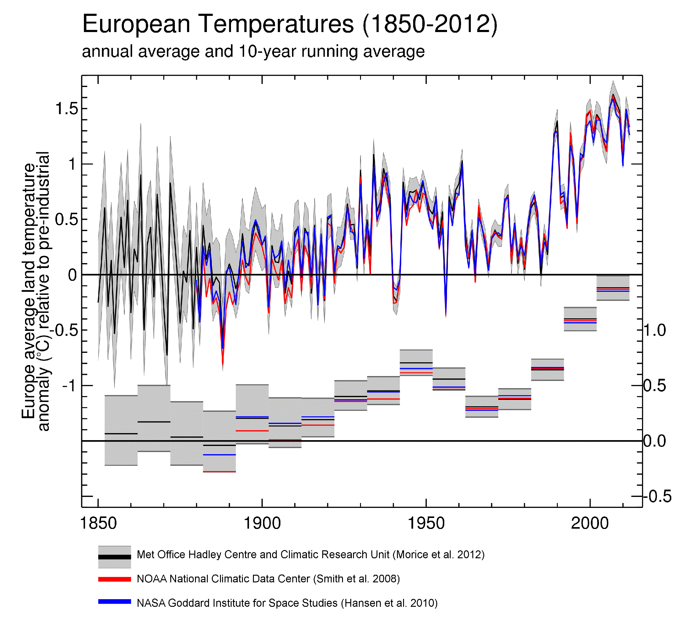
The European mean annual temperature deviations are in the source in relation to the base period 1961-1990. The annual deviations shown in the chart have been adjusted to be relative to the period 1850-1899 to better monitor the EU objective not to exceed 2ºC above pre-industrial values. Over Europe average annual temperatures during the real pre-industrial period (1750-1799) were very similar to those during 1850-99. Europe is defined as the area between 35º to 70º Northern latitude, -25º to 30º Eastern longitude, plus Turkey (=35º to 40º North, 30º to 45º East). The resulting temperature anomalies were obtained using KNMI climate explorer.


Geographical coverage note: Europe

Permalinks

Geographic coverage

Temporal coverage

Topics

Tags

Filed under:
Filed under: climate change, climate
Document Actions